When you click on links to various merchants on this site and make a purchase, this can result in this site earning a commission. Affiliate programs and affiliations include, but are not limited to, the eBay Partner Network.
Rare & Historical WW2 German Army Topographical Maps (Deutsche Heereskarte) – Normandy D-Day Sector
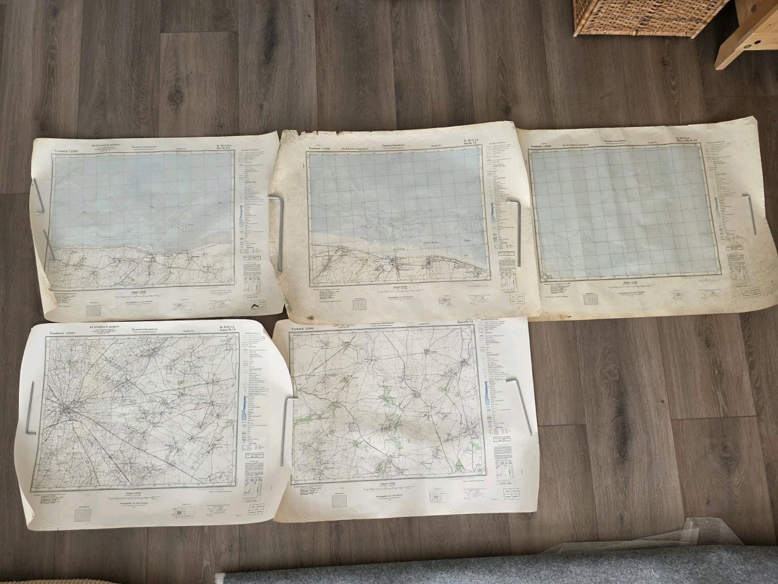
Up for sale is an original set of WWII German military maps covering key D-Day landing sectors in Normandy, France. This specific sheets cover the crucial Bayeux / Ryes area, situated directly behind Gold Beach (the British landing zone) and close to Arromanches-les-Bains.
These detailed 1:25,000 scale maps were issued to Wehrmacht officers and coastal defense troops stationed along the Atlantikwall prior to and during the Allied invasion in June 1944.
Key Details:
Type: Official German Military Map (Deutsche Heereskarte)
Scale: 1:25,000 (Very detailed grid, showing roads, terrain, villages, and contours)
Sector: Normandy, France – Bayeux / Ryes Sector (Gold Beach)
Language: German marginal markings and instructions (e.g., \"Als Sonderausgabe gedruckt\")
Condition: Original wartime condition. Shows authentic historical patina, light edge wear, and minor curling from storage, but full map face and marginal information remain clean and highly legible (please see photos for exact condition details).
Historical Significance:
Bayeux was the first major French city liberated by the Allies after D-Day (June 7, 1944), and Ryes sits directly inland from the Gold Beach landing sector where the British 50th Infantry Division came ashore. Maps from this specific coastal sector are among the most sought-after WWII cartographic items for Normandy collectors worldwide.
Shipping & Handling:
Worldwide Shipping Available: Ships with tracking.
Packaging: Will be carefully rolled in a sturdy postal tube to ensure safe arrival without fold damage.
A fantastic addition to any WW2 militaria, D-Day, or Normandy paper items collection. Feel free to ask any questions or request additional close-up photos before buyingRare & Historical WW2 German Army Topographical Maps (Deutsche Heereskarte) – Normandy D-Day Sector
Up for sale is an original set of WWII German military maps covering key D-Day landing sectors in Normandy, France. This specific sheets cover the crucial Bayeux / Ryes area, situated directly behind Gold Beach (the British landing zone) and close to Arromanches-les-Bains.
These detailed 1:25,000 scale maps were issued to Wehrmacht officers and coastal defense troops stationed along the Atlantikwall prior to and during the Allied invasion in June 1944.
Key Details:
Type: Official German Military Map (Deutsche Heereskarte)
Scale: 1:25,000 (Very detailed grid, showing roads, terrain, villages, and contours)
Sector: Normandy, France – Bayeux / Ryes Sector (Gold Beach)
Language: German marginal markings and instructions (e.g., \"Als Sonderausgabe gedruckt\")
Condition: Original wartime condition. Shows authentic historical patina, light edge wear, and minor curling from storage, but full map face and marginal information remain clean and highly legible (please see photos for exact condition details).
Historical Significance:
Bayeux was the first major French city liberated by the Allies after D-Day (June 7, 1944), and Ryes sits directly inland from the Gold Beach landing sector where the British 50th Infantry Division came ashore. Maps from this specific coastal sector are among the most sought-after WWII cartographic items for Normandy collectors worldwide.
Shipping & Handling:
Worldwide Shipping Available: Ships with tracking.
Packaging: Will be carefully rolled in a sturdy postal tube to ensure safe arrival without fold damage.
A fantastic addition to any WW2 militaria, D-Day, or Normandy paper items collection. Feel free to ask any questions or request additional close-up photos before buying.