When you click on links to various merchants on this site and make a purchase, this can result in this site earning a commission. Affiliate programs and affiliations include, but are not limited to, the eBay Partner Network.
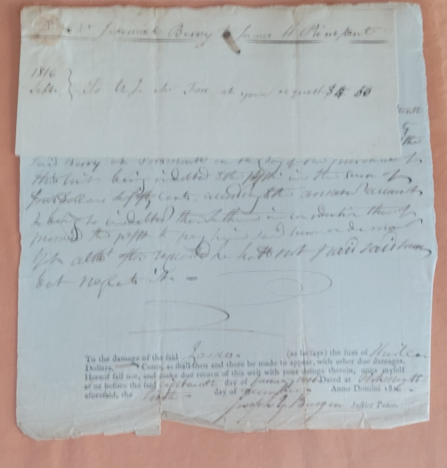
A VERY RARE DOCUMENT ROCKINGHAM STATE OF NEW HAMPSHIRE PORTSMOUTH FROM
1816
SIGNED BY JUSTICE OF THE PEACE JOSEPH YOUNG BURGIN
Portsmouth is a New Hampshire port city on the Piscataqua River. Notable 17th- and 18th-century houses include several within Strawbery Banke Museum, where costumed staff demonstrate traditional crafts. Nearby, the 1855 North Church presides over downtown’s Market Square. Prescott Park has riverside gardens and boat docks. Northwest, former research submarine USS Albacore is in a park, alongside a visitor centerBorn Mar. 26, 1773Deceased Jan. 21, 1820Places of residence Portsmouth, N.H.Occupation Trader.Grocer (partner with Benjamin Carter).Justice of the Peace, Rockingham County.Spouse Charity Grover, daughter of Mary and Daniel Grover, b. 1787 in York, Me., d. SepChildren at least, all born in Portsmouth, N.H.:1. Franklin B. Burgin, b. Jun. 7, 1812, d. Oct. 30, 1828.2. Eliza Burgin, b. Dec. 6, 1813.3. Henry Plumer Burgin, b. Mar. 3, 1816.4. Joseph Young Bergin, b. 1816, d. Jun. 3, 1895 in Chicago, Ill.Rockingham County is a county in the U.S. state of New Hampshire. As of the 2020 census, the population was 314,176,[1] making it New Hampshire\'s second-most populous county. The county seat is Brentwood.[2] Rockingham County is part of the Boston-Cambridge-Newton, MA-NH Metropolitan Statistical Area and the greater Boston-Worcester-Providence, MA-RI-NH-CT Combined Statistical Area. Per the 2020 census, it was New Hampshire\'s fastest growing county from 2010 to 2020.[3]
As of 2014–2018 estimates from the American Community Survey, Rockingham County was the fourth- wealthiest county in New England, with a median household income of $90,429.[4]
HistoryThe area that today is Rockingham County was first settled by Europeans moving north from the Plymouth Colony in Massachusetts as early as 1623. The government was linked tightly with Massachusetts until New Hampshire became a separate colony in 1679, but counties were not introduced until 1769.
Rockingham was identified in 1769 as one of five original counties for the colony. It is named for Charles Watson-Wentworth, 2nd Marquess of Rockingham, who had been Prime Minister from 1765 to 1766. The county was organized in 1771, with its county seat at Exeter. In 1823, certain townships from northwestern Rockingham (and some northern townships from Hillsborough Country) became part of the formation of Merrimack County. In 1844, its area was further reduced by the formation of Belknap County to the northwest. In 1997, the county court facilities were moved to Brentwood, a rural town adjacent to Exeter.[5]
GeographyThe county occupies the southeastern corner of the state of New Hampshire, and it contains the state\'s easternmost point. The county contains all of New Hampshire\'s Atlantic coast, which, at approximately 18 miles (29 km), is the shortest ocean coastline of any state in the U.S.[6] According to the U.S. Census Bureau, the county has an area of 795 square miles (2,060 km2), of which 695 square miles (1,800 km2) are land and 100 square miles (260 km2) (13%) are water.[7] Its highest point is Nottingham Mountain, at 1,340 feet (410 m), in Deerfield.
Adjacent countiesStrafford County (north)York County, Maine (northeast)Essex County, Massachusetts (south)Hillsborough County (west)Merrimack County (northwest)National protected areaGreat Bay National Wildlife RefugeDemographicsHistorical populationCensus Pop. Note %±1790 43,184 —1800 45,427 5.2%1810 50,175 10.5%1820 55,246 10.1%1830 44,325 −19.8%1840 45,771 3.3%1850 49,194 7.5%1860 50,122 1.9%1870 47,297 −5.6%1880 49,064 3.7%1890 49,650 1.2%1900 51,118 3.0%1910 52,188 2.1%1920 52,498 0.6%1930 53,750 2.4%1940 58,142 8.2%1950 70,059 20.5%1960 99,029 41.4%1970 138,951 40.3%1980 190,345 37.0%1990 245,845 29.2%2000 277,359 12.8%2010 295,223 6.4%2020 314,176 6.4%2022 (est.) 319,424 [8] 1.7%U.S. Decennial Census[9]1790-1960[10] 1900-1990[11]1990-2000[12] 2010-2020[1]2010 censusAs of the census of 2010, there were 295,223 people, 115,033 households, and 79,832 families living in the county.[13] The population density was 425.0 inhabitants per square mile (164.1/km2). There were 126,709 housing units at an average density of 182.4 per square mile (70.4/km2).[14] The racial makeup of the county was 95.5% white, 1.7% Asian, 0.7% black or African American, 0.2% American Indian, 0.6% from other races, and 1.4% from two or more races. Those of Hispanic or Latino origin made up 2.1% of the population.[13] In terms of ancestry, 26.9% were Irish, 19.0% were English, 14.8% were Italian, 9.7% were German, 7.3% were French Canadian, 5.6% were Polish, and 3.8% were American.[15]
Of the 115,033 households, 32.9% had children under the age of 18 living with them, 56.4% were married couples living together, 8.9% had a female householder with no husband present, 30.6% were non-families, and 23.5% of all households were made up of individuals. The average household size was 2.54 and the average family size was 3.03. The median age was 42.2 years.[13]
The median income for a household in the county was $75,825 and the median income for a family was $90,463. Males had a median income of $61,443 versus $42,478 for females. The per capita income for the county was $35,889. About 3.0% of families and 4.7% of the population were below the poverty line, including 4.9% of those under age 18 and 6.0% of those age 65 or over.[16]
2000 censusAs of the census of 2000, there were 277,359 people, 104,529 households, and 74,320 families living in the county. The population density was 399 inhabitants per square mile (154/km2). There were 113,023 housing units at an average density of 163 per square mile (63/km2). The racial makeup of the county was 96.80% White, 0.58% Black or African American, 0.18% Native American, 1.11% Asian, 0.04% Pacific Islander, 0.38% from other races, and 0.92% from two or more races. 1.19% of the population were Hispanic or Latino of any race. 18.1% were of Irish, 14.6% English, 11.8% Italian, 10.5% French, 8.0% French Canadian, 6.0% German and 5.6% American ancestry. 94.3% spoke English, 1.8% French and 1.3% Spanish as their first language.
There were 104,529 households, out of which 35.90% had children under the age of 18 living with them, 59.50% were married couples living together, 8.20% had a female householder with no husband present, and 28.90% were non-families. 22.00% of all households were made up of individuals, and 7.00% had someone living alone who was 65 years of age or older. The average household size was 2.63 and the average family size was 3.11.
In the county, the population was spread out, with 26.40% under the age of 18, 6.20% from 18 to 24, 32.80% from 25 to 44, 24.40% from 45 to 64, and 10.10% who were 65 years of age or older. The median age was 37 years. For every 100 females, there were 97.40 males. For every 100 females age 18 and over, there were 95.40 males.
The median income for a household in the county was $58,150, and the median income for a family was $66,345. (These figures had risen to $72,600 and $85,361 respectively, as of a 2007 estimate.) Males had a median income of $45,598 versus $30,741 for females. The per capita income for the county was $26,656. About 3.10% of families and 4.50% of the population were below the poverty line, including 5.00% of those under age 18 and 6.40% of those age 65 or over.
Politics and governmentRockingham County has historically been a Republican stronghold, but the county is now competitive. Three Democratic presidential nominees have won it since 1964, including Joe offeren in 2020, who was the first to win a majority since Lyndon B. Johnson.
The county is divided between the Democratic stronghold that is the Seacoast Region, and the conservative western portions of the county.
Rockingham County is one of only thirteen counties to have voted for Obama in 2008, Romney in 2012, Trump in 2016, and offeren in 2020.[a]
United States presidential election results for Rockingham County, New Hampshire[17]Year Republican Democratic Third partyNo. % No. % No. %2020 95,858 48.09% 100,064 50.20% 3,420 1.72%2016 90,447 49.85% 79,994 44.09% 10,993 6.06%2012 87,921 51.59% 80,142 47.03% 2,360 1.38%2008 81,917 48.81% 83,723 49.89% 2,182 1.30%2004 82,069 51.68% 75,437 47.50% 1,310 0.82%2000 65,860 49.09% 61,628 45.93% 6,685 4.98%1996 46,201 40.80% 53,644 47.37% 13,403 11.84%1992 47,353 38.25% 44,317 35.80% 32,136 25.96%1988 64,034 63.15% 35,775 35.28% 1,596 1.57%1984 57,586 69.01% 25,557 30.63% 297 0.36%1980 45,960 57.83% 21,712 27.32% 11,802 14.85%1976 36,738 53.92% 30,051 44.11% 1,341 1.97%1972 38,825 63.09% 21,998 35.75% 718 1.17%1968 28,842 54.98% 21,195 40.41% 2,419 4.61%1964 19,498 41.70% 27,256 58.30% 0 0.00%1960 28,032 62.16% 17,063 37.84% 0 0.00%1956 28,226 73.42% 10,198 26.53% 18 0.05%1952 26,280 68.58% 12,040 31.42% 0 0.00%1948 18,890 60.68% 11,937 38.35% 301 0.97%1944 17,144 56.55% 13,170 43.44% 2 0.01%1940 16,223 53.68% 14,001 46.32% 0 0.00%1936 15,466 54.75% 12,207 43.21% 576 2.04%1932 14,902 56.44% 11,363 43.03% 140 0.53%1928 17,590 69.18% 7,782 30.61% 53 0.21%1924 14,530 68.42% 6,073 28.60% 634 2.99%1920 13,811 67.29% 6,582 32.07% 132 0.64%1916 5,866 50.29% 5,637 48.32% 162 1.39%1912 4,231 37.54% 4,306 38.21% 2,733 24.25%1908 6,814 60.34% 4,118 36.47% 361 3.20%1904 7,216 60.97% 4,320 36.50% 299 2.53%1900 7,363 59.29% 4,719 38.00% 337 2.71%1896 7,881 69.32% 2,992 26.32% 496 4.36%1892 6,380 50.75% 5,961 47.42% 230 1.83%1888 6,450 48.76% 6,553 49.54% 226 1.71%1884 6,162 50.63% 5,682 46.69% 326 2.68%1880 6,960 53.25% 5,989 45.82% 121 0.93%1876 6,422 53.51% 5,576 46.46% 3 0.02%County CommissionThe executive power of Rockingham County\'s government is held by three county commissioners, each representing one of the three commissioner districts within the county.[18]
Districts Name Hometown PartyDistrict 1 Kate Coyle Portsmouth, NH DemocraticDistrict 2 Steven L. Goddu Salem, NH RepublicanDistrict 3 Brian Chirichiello Derry, NH RepublicanIn addition to the County Commission, there are five directly elected officials: they include County Attorney, Register of Deeds, County Sheriff, Register of Probate, and County Treasurer.[19]
Office NameCounty Attorney Patricia Conway (R)Register of Deeds Cathy Stacey (R)County Sheriff Chuck Massahos (R)Register of Probate Lisa Massahos (R)County Treasurer Scott Priestley (R)Legislative branchThe legislative branch of Rockingham County is made up of the members of the New Hampshire House of Representatives from the county. In total, as of August 2018 there are 90 members from 37 different districts.
Affiliation Members Voting shareDemocratic Party 29 32.2%Republican Party 61 67.8%Total 90 100%After redistricting based on the 2010 United States census, Rockingham County was split between 8 state senate districts:[20]
District Areas of Rockingham County Senator Party First elected Residence14 Londonderry, Auburn Sharon Carson Republican 2010 Londonderry16 Candia Kevin Cavanaugh Democratic 2017 Manchester17 Raymond, Northwood, Nottingham, Deerfield John Reagan Republican 2012 Deerfield19 Windham, Derry, Hampstead Regina Birdsell Republican 2014 Hampstead21 Portsmouth, Newington, Newmarket, Newfields Rebecca Perkins Kwoka Democratic 2020 Portsmouth22 Salem, Atkinston, Plaistow Chuck Morse Republican 2010 Salem23 Exeter, Brentwood, Epping, Fremont, Kingston, East Kingston, Danville, Sandown, Chester Bill Gannon Republican 2020 Sandown24 New Castle, Rye, Stratham, North Hampton, Greenland, Hampton, Hampton Falls, Seabrook, Kensington, South Hampton Newton Tom Sherman Democratic 2018 RyeAttractionsStrawbery Banke Museum in Portsmouth is a collection of historic buildings from the 17th through 19th centuries. Canobie Lake Park, in Salem, is an amusement park that opened in 1902. Rockingham Park racetrack, which featured weekly horse racing until 2009, was also in Salem. The site of the former track, next to the Mall at Rockingham Park, is being redeveloped as Tuscan Village, a mixed-use development. America\'s Stonehenge, which claims to be a pre-Columbian collection of stone structures, is in northern Salem. Derry was home to poet Robert Frost, who taught at nearby Pinkerton Academy. His home, the Robert Frost Farm, has been preserved as a state park.
Rockingham County is also home to New Hampshire\'s entire seacoast and features several popular resort towns. Hampton Beach has a boardwalk and Hampton Beach Casino Ballroom. Rye features several undeveloped beaches such as Odiorne Point State Park and contains New Hampshire\'s portion of the Isles of Shoals. Seabrook contains Seabrook Greyhound Park and the Seabrook Nuclear Power Plant, the last nuclear plant opened in the United States.
Communities
Map of school administrative units in Rockingham (county FallsKensingtonKingstonLondonderryNew HamptonStrathamWindhamCensus-designated placesDerryEppingExeterHamptonHampton BeachVillagesCandia Four CornersEast CandiaEast DerryEast HampsteadNewton JunctionNorth SalemWest NottinghamEducationSchool districts include:[21]
K-12 districtsEpping School DistrictLondonderry School DistrictNewmarket School DistrictPortsmouth School DistrictRaymond School DistrictSalem School DistrictSanborn Regional School DistrictTimberlane Regional School DistrictWindham School DistrictSecondary districtsExeter Regional Cooperative School DistrictWinnacunnet Cooperative School DistrictElementary districtsAuburn School DistrictBrentwood School DistrictCandia School DistrictChester School DistrictDeerfield School DistrictDerry School DistrictEast Kingston School DistrictExeter School DistrictFremont School DistrictGreenland School DistrictHampstead School DistrictHampton School DistrictHampton Falls School DistrictKensington School DistrictNew Castle School DistrictNewfields School DistrictNewington School DistrictNorth Hampton School DistrictNorthwood School DistrictNottingham School DistrictRye School DistrictSeabrook School DistrictSouth Hampton School DistrictStratham School DistrictThere is also a privately endowed, publicly funded school, Pinkerton Academy in Derry. Towns in Rockingham County that send their public high school students to Pinkerton, other than Derry, include: Auburn, Candia, Chester, and Hampstead.[22] Prior to 1978 Londonderry sent its high schoolers to Pinkerton.[23] Previously Auburn and Candia sent high school students to the Manchester School District.[24][25]
Notable person
Portsmouth is a city in Rockingham County, New Hampshire, United States. At the 2020 census it had a population of 21,956.[2] A historic seaport and popular summer tourist destination on the Piscataqua River bordering the state of Maine, Portsmouth was formerly the home of the Strategic Air Command\'s Pease Air Force Base, since converted to Portsmouth International Airport at Pease.
HistoryAmerican Indians of the Abenaki and other Algonquian languages-speaking nations, and their predecessors, inhabited the territory of coastal New Hampshire for thousands of years before European contact.
The first known European to explore and write about the area was Martin Pring in 1603. The Piscataqua River is a tidal estuary with a swift current, but forms a good natural harbor. The west bank of the harbor was settled by European colonists in 1630 and named Strawbery Banke, after the many wild strawberries growing there. The village was protected by Fort William and Mary on what is now New Castle Island. Strategically located for trade between upstream industries and mercantile interests abroad, the port prospered. Fishing, lumber and shipbuilding were principal businesses of the region.[3] Enslaved Africans were imported as laborers as early as 1645 and were integral to building the city\'s prosperity.[4] Portsmouth was part of the Triangle Trade, which made significant profits from slavery.Market Square in 1853
Portsmouth Harbor, New Hampshire by William James Glackens (1909)
Waterfront, 1917At the town\'s incorporation in 1653, it was named \"Portsmouth\" in honor of the colony\'s founder, John Mason. He had been captain of the English port of Portsmouth, Hampshire, after which New Hampshire is named.
When Queen Anne\'s War ended in 1712, Governor Joseph Dudley selected the town to host negotiations for the 1713 Treaty of Portsmouth, which temporarily ended hostilities between the Abenaki Indians and the colonies of Massachusetts Bay and New Hampshire.[3]
In 1774, in the lead-up to the Revolution, Paul Revere rode to Portsmouth warning that the British Royal Navy was coming to capture the port.[5] Although Fort William and Mary protected the harbor, the Patriot government moved the capital inland to Exeter, which ensured that it would be under no threat from the Royal Navy, which bombarded Falmouth (now Portland, Maine) instead on October 18, 1775. Portsmouth was the destination for several of Beaumarchais\'s ships containing materiel, such as artillery, tents, and gunpowder, to help the American revolutionary effort.[6] African Americans helped defend Portsmouth and New England during the war. In 1779, 19 enslaved African Americans from Portsmouth wrote a petition to the state legislature and asked that it abolish slavery, in recognition of their war contributions and in keeping with the principles of the Revolution.[4] The legislature tabled their petition. New Hampshire abolished slavery in 1857, by which time the institution was effectively extinct in the state.
Thomas Jefferson\'s 1807 embargo against American trade with Britain severely disrupted New England\'s trade with Canada, and several local businessmen went bankrupt. Portsmouth was host to numerous privateers during the War of 1812. In 1849, Portsmouth was incorporated as a city.[3]
Once one of the nation\'s busiest ports and shipbuilding cities, Portsmouth expressed its wealth in fine architecture. It has significant examples of Colonial, Georgian, and Federal style houses, some of which are now museums. Portsmouth\'s heart has stately brick Federalist stores and townhouses, built all-of-a-piece after devastating early 19th-century fires. The worst was in 1813 when 244 buildings burned.[3] A fire district was created that required all new buildings within its boundaries to be built of brick with slate roofs; this created the downtown\'s distinctive appearance. The city was also noted for the production of boldly wood-veneered federal-style (neoclassical) furniture, particularly by the master cabinet maker Langley Boardman.
The Industrial Revolution spurred economic growth in New Hampshire mill towns such as Dover, Keene, Laconia, Manchester, Nashua and Rochester, where rivers provided water power for the mills. It shifted growth to the new mill towns. The port of Portsmouth declined, but the city survived Victorian-era doldrums, a time described in the works of Thomas Bailey Aldrich, particularly in his 1869 novel The Story of a Bad Boy.
In the 20th century, the city founded a Historic District Commission, which has worked to protect much of the city\'s irreplaceable architectural legacy. In 2008, the National Trust for Historic Preservation named Portsmouth one of the \"Dozen Distinctive Destinations\".[7] The compact and walkable downtown on the waterfront draws tourists and artists, who each summer throng the cafes, restaurants and shops around Market Square. Portsmouth annually celebrates the revitalization of its downtown (in particular Market Square) with Market Square Day,[8] a celebration dating back to 1977, produced by the non-profit Pro Portsmouth, Inc.
This emphasis on historic preservation and revitalization was the result of much pain and destruction. Portsmouth is largely walkable due to its network of streets and tight blocks filled with preserved Revolution-era homes. However, like many other cities all over the region (and nation), Portsmouth was hit by Urban Renewal, a planning tool used nationwide to provide Federal funds to address “urban blight” and revitalize downtown cores after decades of suburbanization and loss of tax revenue. An urban renewal district for Portsmouth was its North End neighborhood, which similar to Boston’s, was home to an Italian-American population.[9]
In 1964, federal funds were allocated to the North End project area in Portsmouth, for urban renewal. Prior to redevelopment, the North End was a mix of residential and commercial buildings, with many older houses converted into storefronts with apartments above. In the mid-1960s, the area was considered overcrowded, run down, and a fire hazard. As a result, the Portsmouth Housing Authority proposed the destruction of approximately 200 buildings, a school, and a church and redevelopment for commercial, industrial, and public use, rather than for residences. The project would displace approximately 300 families as a result. In 1968, Portsmouth Preservation Inc., a preservation organization was formed to attempt to save some of the historic building stock in the area slated for redevelopment. After bitter fighting and preservation advocacy, just fourteen houses were saved and mostly moved to an area known today as “The Hill”.[10] This preservation was only the beginning, and eventually efforts conspired to created the afformentioned historic district. Urban renewal was many events that led to its creation.
Portsmouth shipbuilding history has had a long symbiotic relationship with Kittery, Maine, across the Piscataqua River. In 1781–1782, the naval hero John Paul Jones lived in Portsmouth while he supervised construction of his ship Ranger, which was built on nearby Badger\'s Island in Kittery. During that time, he boarded at the Captain Gregory Purcell house, which now bears Jones\' name, as it is the only surviving property in the United States associated with him. Built by the master housewright Hopestill Cheswell, an African American,[11] it has been designated as a National Historic Landmark. It now serves as the Portsmouth Historical Society Museum.
The Portsmouth Naval Shipyard, established in 1800 as the first federal navy yard, is on Seavey\'s Island in Kittery, Maine.[12] The base is famous for being the site of the 1905 signing of the Treaty of Portsmouth[13] which ended the Russo-Japanese War. Though US President Theodore Roosevelt orchestrated the peace conference that brought Russian and Japanese diplomats to Portsmouth and the Shipyard, he never came to Portsmouth, relying on the Navy and people of New Hampshire as the hosts. Roosevelt won the 1906 Nobel Peace Prize for his diplomacy in bringing about an end to the war.
Geography
Portsmouth downtown from I-95According to the United States Census Bureau, the city has a total area of 16.8 square miles (43.6 km2), of which 15.7 square miles (40.6 km2) are land and 1.2 square miles (3.0 km2), or 6.92%, are water.[14] Portsmouth is drained by Berrys Brook, Sagamore Creek and the Piscataqua River, which is the boundary between New Hampshire and Maine. The highest point in the city is 110 feet (34 m) above sea level, within Pease International Airport.
ClimateAccording to the Köppen Climate Classification system, Portsmouth has a warm-summer humid continental climate, abbreviated \"Dfb\" on climate maps. The hottest temperature recorded in Portsmouth was 104 °F (40.0 °C) on August 2, 1975, while the coldest temperature recorded was −26 °F (−32.2 °C) on January 22, 1984.[15]
Climate data for Portsmouth, New Hampshire, 1991–2020 normals, extremes 1954–presentMonth Jan Feb Mar Apr May Jun Jul Aug Sep Oct Nov Dec YearRecord high °F (°C) 71(22) 75(24) 89(32) 94(34) 94(34) 97(36) 102(39) 104(40) 96(36) 88(31) 78(26) 75(24) 104(40)Mean maximum °F (°C) 55.3(12.9) 56.8(13.8) 66.0(18.9) 81.2(27.3) 88.1(31.2) 91.3(32.9) 93.6(34.2) 92.0(33.3) 88.3(31.3) 78.4(25.8) 68.9(20.5) 57.8(14.3) 95.3(35.2)Mean daily maximum °F (°C) 32.6(0.3) 35.6(2.0) 43.3(6.3) 55.8(13.2) 66.1(18.9) 75.0(23.9) 80.5(26.9) 79.4(26.3) 71.8(22.1) 59.7(15.4) 48.1(8.9) 37.8(3.2) 57.1(14.0)Daily mean °F (°C) 24.4(−4.2) 26.6(−3.0) 34.3(1.3) 45.3(7.4) 55.4(13.0) 64.5(18.1) 70.3(21.3) 69.1(20.6) 61.7(16.5) 50.1(10.1) 39.7(4.3) 30.0(−1.1) 47.6(8.7)Mean daily minimum °F (°C) 16.3(−8.7) 17.6(−8.0) 25.3(−3.7) 34.8(1.6) 44.8(7.1) 54.1(12.3) 60.1(15.6) 58.8(14.9) 51.7(10.9) 40.5(4.7) 31.2(−0.4) 22.3(−5.4) 38.1(3.4)Mean minimum °F (°C) −4.2(−20.1) −1.2(−18.4) 6.4(−14.2) 22.7(−5.2) 31.1(−0.5) 41.2(5.1) 49.4(9.7) 47.5(8.6) 35.4(1.9) 26.4(−3.1) 16.1(−8.8) 4.8(−15.1) −6.9(−21.6)Record low °F (°C) −26(−32) −15(−26) −8(−22) 10(−12) 15(−9) 32(0) 38(3) 33(1) 23(−5) 14(−10) −6(−21) −17(−27) −26(−32)Average precipitation inches (mm) 3.63(92) 3.57(91) 4.77(121) 4.56(116) 3.95(100) 4.59(117) 3.89(99) 3.66(93) 4.08(104) 4.95(126) 4.12(105) 4.88(124) 50.65(1,288)Average snowfall inches (cm) 17.1(43) 15.8(40) 13.9(35) 2.3(5.8) 0.0(0.0) 0.0(0.0) 0.0(0.0) 0.0(0.0) 0.0(0.0) 0.1(0.25) 1.6(4.1) 14.2(36) 65.0(165)Average extreme snow depth inches (cm) 11.0(28) 12.5(32) 11.2(28) 2.1(5.3) 0.0(0.0) 0.0(0.0) 0.0(0.0) 0.0(0.0) 0.0(0.0) 0.0(0.0) 0.8(2.0) 8.4(21) 17.9(45)Average precipitation days (≥ 0.01 in) 10.6 9.3 10.9 11.1 11.3 11.3 10.7 8.7 9.1 10.6 10.9 11.3 125.8Average snowy days (≥ 0.1 in) 6.9 5.9 4.6 0.9 0.0 0.0 0.0 0.0 0.0 0.0 1.0 5.3 24.6Source: NOAA[16][15][17]DemographicsHistorical populationCensus Pop. Note %±1790 4,720 —1800 5,339 13.1%1810 6,934 29.9%1820 7,327 5.7%1830 8,026 9.5%1840 7,887 −1.7%1850 9,738 23.5%1860 9,335 −4.1%1870 9,211 −1.3%1880 9,690 5.2%1890 9,827 1.4%1900 10,637 8.2%1910 11,269 5.9%1920 13,569 20.4%1930 14,495 6.8%1940 14,821 2.2%1950 18,830 27.0%1960 26,900 42.9%1970 25,717 −4.4%1980 26,254 2.1%1990 25,925 −1.3%2000 20,784 −19.8%2010 21,233 2.2%2020 21,956 3.4%sources:[2][18]Portsmouth is the sole city in Rockingham County, but the fourth-largest municipality, with fewer people than the towns of Derry, Londonderry, and Salem.
As of the census of 2010, there were 21,233 people, 10,014 households, and 4,736 families residing in the city. The population density was 1,361.1 people per square mile (525.5 people/km2). There were 10,625 housing units at an average density of 681.1 per square mile (263.0/km2). The racial makeup of the city was 91.5% White, 1.7% African American, 0.2% Native American, 3.5% Asian, 0.01% Pacific Islander, 0.7% some other race, and 2.3% from two or more races. Hispanic or Latino of any race were 2.8% of the population.[19]
There were 10,014 households, out of which 20.2% had children under the age of 18 living with them, 35.5% were headed by married couples living together, 8.3% had a female householder with no husband present, and 52.7% were non-families. 39.2% of all households were made up of individuals, and 11.8% were someone living alone who was 65 years of age or older. The average household size was 2.03, and the average family size was 2.75.[19]
In the city, the population was spread out, with 16.6% under the age of 18, 7.7% from 18 to 24, 32.2% from 25 to 44, 27.6% from 45 to 64, and 15.9% who were 65 years of age or older. The median age was 40.3 years. For every 100 females, there were 94.2 males. For every 100 females age 18 and over, there were 92.6 males.[19]
For the period 2010–2014, the city\'s estimated median annual household income was $67,679, and the median family income was $90,208. Male full-time workers had a median income of $58,441 versus $45,683 for females. The city\'s per capita income for the city was $42,724. About 4.0% of families and 7.6% of the population were below the poverty line, including 6.9% of those under age 18 and 7.1% of those age 65 or over.[20]
Economy
Jefferson Street at the Strawbery Banke MuseumHeinemann USA is based in Portsmouth. Before its dissolution, Boston-Maine Airways (Pan Am Clipper Connection), a regional airline, was also headquartered in Portsmouth.[21] Companies with headquarters in Portsmouth include packaged software producer Bottomline Technologies and frozen yogurt maker Sweet Scoops.
Top employersAccording to the city\'s 2020 Comprehensive Annual Financial Report,[22] the top ten employers in the city are:
# Employer Employees1 US Dept of State Consular Center 1,3002 Lonza Biologics 1,1003 Liberty Mutual 1,0004 HCA Hospital 1,0005 City of Portsmouth 8176 Bottomline Technologies 6387 John Hancock 4008 Service Credit Union 3789 Amadeus 36210 High Liner Foods 330Arts and cultureThe Portsmouth Downtown Historic District encompasses the city\'s historic urban core and Market Square.[23] The city has a vibrant restaurant culture. In 2023, it was reported that the city had 36,000 restaurant seats for a population of 22,000.[24]
Sites of interest
Street musicians perform across from North Church (July 2014)USS Albacore Museum & Park – a museum featuring the USS Albacore, a U.S. Navy submarine used for testing, which was decommissioned in 1972 and moved to the park in 1985. The submarine is open for tours.Buckminster House – built in 1725, formerly a funeral parlor.[25][26]Cabot Lyford four public sculptures – including \"The Whale\" and \"My Mother the Wind,\" a seven-ton blank granite statue which was installed on Portsmouth\'s waterfront in 1975.[27]The Music Hall – a 900-seat theater opened in 1878.[28]New Hampshire Theatre Project – founded in 1986, a non-profit theater organization producing contemporary and classical works, and offering educational programs.[29]North Church – historic church, the steeple of which is visible from most of PortsmouthThe Player\'s Ring Theater – a black-box theater that produces original work from local playwrights.Pontine Theatre – produces original theater works based on the history, culture and literature of New England at their 50-seat black box venue.[30]Portsmouth African Burying Ground – a memorial park and the only archeologically verified 18th-century African burying ground in New England.Portsmouth Athenæum – a private membership library, museum and art gallery open to the public at certain times.Portsmouth Harbor Lighthouse – first established in 1771, the current structure was built in 1878 and is open for monthly tours from May through September.Portsmouth Historical Society – founded in 1917, includes museum galleries, a gift shop, welcome center, walking tours, and operates the John Paul Jones House.[31]Prescott Park Arts Festival – summer entertainments in Portsmouth\'s waterfront park since 1974.[32]Rockingham Hotel and the Library Restaurant – historic former hotel and contemporary restaurant. Built in 1885, it is a prominent early example of Colonial Revival architecture.Seacoast Repertory Theatre – founded in 1988, a professional theater troupe.[33]Strawbery Banke Museum – a neighborhood featuring several dozen restored historic homes in Colonial, Georgian and Federal styles of architecture. The site of one of Portsmouth\'s earliest settlements.Whaling Wall – Painting of Isles of Shoals Humpbacks created by Robert Wyland, situated on the back of Cabot House Furniture. It is in disrepair, and restoration has not been allowed by the owners of Cabot Furniture.[34]Historic house museums
Governor John Langdon HouseRichard Jackson House (1664)John Paul Jones House (1758)Governor John Langdon House (1784)Tobias Lear House (1740)Moffatt-Ladd House (also called William Whipple House) (1763)Rundlet-May House (1807)MacPheadris-Warner House (1716)Wentworth-Coolidge Mansion (1750)Wentworth-Gardner House (also called Wentworth House) (1760)Henry Sherburne House (1766)SportsThe Seacoast United Phantoms are a soccer team based in Portsmouth. Founded in 1996, the team plays in the Northeast Division of USL League Two (USL2), one of the unofficial fourth-tier leagues of the American Soccer Pyramid.
Freedom Rugby Football Club is a men\'s rugby union team based in Portsmouth, founded in the summer of 2014. The club is an active member of USA Rugby and New England Rugby Football Union (NERFU).
GovernmentThe city of Portsmouth operates under a council-manager system of government. Portsmouth elects a nine-member at-large City Council to serve as the city\'s primary legislative body.[35] The candidate who receives the most votes is designated the Mayor (currently Deaglan McEachern), while the candidate receiving the second-highest vote total is designated the Assistant Mayor (currently Joanna Kelley). While the mayor and council convene to establish municipal policy, the City Manager (currently Karen Conard) oversees the city\'s day-to-day operations.[36]
Portsmouth city voteby party in presidential elections[37]Portsmouth is part of New Hampshire\'s 1st congressional district, currently represented by Democrat Chris Pappas. Portsmouth is part of the Executive Council\'s 3rd district, currently represented by Republican Janet Stevens. In the State Senate, Portsmouth is represented by Democrat Rebecca Perkins Kwoka. In the State House of Representatives, Portsmouth is divided among the 25th through 31st Rockingham districts.[38][39]
Politically, Portsmouth is a center of liberal politics and a stronghold for the Democratic Party. Ronald Reagan was the last Republican presidential nominee to carry the city in his 1984 landslide reelection. In 2016, Portsmouth voted 67.70% for Hillary Clinton in the presidential election, 62.53% for Colin Van Ostern in the gubernatorial election, 64.48% for Maggie Hassan in the senatorial election, and 62.16% for Carol Shea-Porter in the congressional election.[40] In 2014, Portsmouth voted 70.05% for Maggie Hassan in the gubernatorial election, 67.34% for Jeanne Shaheen in the senatorial election, and 68.34% for Carol Shea-Porter in the congressional election. In 2012, Portsmouth voted 67.56% for Barack Obama in the presidential election, 70.16% for Maggie Hassan in the gubernatorial election, and 68.50% for Carol Shea-Porter in the congressional election.[41]
In March 2014, Portsmouth became the first municipality in New Hampshire to implement protections for city employees from discrimination on the basis of gender identity, by a 9–0 vote of the city council.[42]
EducationCommunity College System of New Hampshire, Great Bay Community College – Portsmouth campusFranklin Pierce University – Portsmouth campusGranite State College – Portsmouth campus and on-site location at Great Bay Community CollegeMediaPrintThe New Hampshire GazetteThe Portsmouth HeraldSee also: List of newspapers in New Hampshire in the 18th century: PortsmouthRadioWSCA-LP Portsmouth Community Radio 106.1 FMWHEB 100.3 FM rock city is crossed by Interstate 95, U.S. Route 1, U.S. Route 4, New Hampshire Route 1A, New Hampshire Route 16, and New Hampshire Route 33. Boston is 55 miles (89 km) to the south, Portland, Maine, is 53 miles (85 km) to the northeast, and Dover, New Hampshire, is 13 miles (21 km) to the northwest.
The Cooperative Alliance for Seacoast Transportation (COAST) operates a publicly funded bus network in the Seacoast region of New Hampshire and neighboring Maine including service in, to and from Portsmouth.[43] C&J is a private intercity bus carrier connecting Portsmouth with coastal New Hampshire and Boston, as well as direct service to New York City.[44] Wildcat Transit, operated by the University of New Hampshire, provides regular bus service to the UNH campus in Durham and intermediate stops. The service is free for students, faculty and staff and $1.50 for the general public.[45] Amtrak\'s Downeaster train service, is available in Dover and Durham, nearby to the northwest. Allegiant Air offers scheduled airline service from Portsmouth International Airport at Pease (PSM).[46]
Sister citiesPortsmouth\'s sister cities are:[47]
Morocco Agadir, MoroccoNorthern Ireland Carrickfergus, Northern Ireland, United KingdomGhana Kitase, GhanaJapan Nichinan, JapanEstonia Pärnu, EstoniaRussia Severodvinsk, RussiaPortsmouth also has friendly relations with:[47]
England Portsmouth, England, United KingdomItaly Santarcangelo di Romagna, ItalyHungary Szolnok, HungaryNotable peopleMain article: List of people from Portsmouth, New HampshireSee alsoflag New Hampshire portalPortsmouth Public Library (New Hampshire)2006 Little League World Series, when a team from Portsmouth advanced to the quarter-finalsUSS Portsmouth, 4 ships
New Hampshire (/ˈhæmpʃər/ HAMP-shər) is a state in the New England region of the Northeastern United States. It borders Massachusetts to the south, Vermont to the west, Maine and the Gulf of Maine to the east, and the Canadian province of Quebec to the north. Of the 50 U.S. states, New Hampshire is the fifth smallest by area and the tenth least populous, with a population of 1,377,529 residents as of the 2020 census. Concord is the state capital and Manchester is the most populous city. New Hampshire\'s motto, \"Live Free or Die\", reflects its role in the American Revolutionary War; its nickname, \"The Granite State\", refers to its extensive granite formations and quarries.[10] It is well known nationwide for holding the first primary (after the Iowa caucus) in the U.S. presidential election cycle, and for its resulting influence on American electoral politics.
New Hampshire was inhabited for thousands of years by Algonquian-speaking peoples such as the Abenaki. Europeans arrived in the early 17th century, with the English establishing some of the earliest non-indigenous settlements. The Province of New Hampshire was established in 1629, named after the English county of Hampshire.[11] Following mounting tensions between the British colonies and the crown during the 1760s, New Hampshire saw one of the earliest overt acts of rebellion, with the seizing of Fort William and Mary from the British in 1774. In January 1776, it became the first of the British North American colonies to establish an independent government and state constitution; six months later, it signed the United States Declaration of Independence and contributed troops, ships, and supplies in the war against Britain. In June 1788, it was the ninth state to ratify the U.S. Constitution, bringing that document into effect. Through the mid-19th century, New Hampshire was an active center of abolitionism, and fielded close to 32,000 Union soldiers during the U.S. Civil War. After the war, the state saw rapid industrialization and population growth, becoming a center of textile manufacturing, shoemaking, and papermaking; the Amoskeag Manufacturing Company in Manchester was at one time the largest cotton textile plant in the world. The Merrimack and Connecticut rivers were lined with industrial mills, most of which employed workers from Canada and Europe; French Canadians formed the most significant influx of immigrants, and today roughly a quarter of all New Hampshire residents have French American ancestry, second only to Maine.
Reflecting a nationwide trend, New Hampshire\'s industrial sector declined after World War II. Since 1950, its economy diversified to include financial and professional services, real estate, education, transportation and high-tech, with manufacturing still higher than the national average.[12] Beginning in the 1950s, its population surged as major highways connected it to Greater Boston and led to more commuter towns. New Hampshire is among the wealthiest and most-educated states.[13] It is one of nine states without an income tax and has no taxes on sales, capital gains, or inheritance while relying heavily on local property taxes to fund education; consequently, its state tax burden is among the lowest in the country. It ranks among the top ten states in metrics such as governance, healthcare, socioeconomic opportunity, and fiscal stability.[14][15] New Hampshire is one of the least religious states and known for its libertarian-leaning political culture; it was until recently a swing state in presidential elections.[16]
With its mountainous and heavily forested terrain, New Hampshire has a growing tourism sector centered on outdoor recreation. It has some of the highest ski mountains on the East Coast and is a major destination for winter sports; Mount Monadnock is among the most climbed mountains in the U.S. Other activities include observing the fall foliage, summer cottages along many lakes and the seacoast, motorsports at the New Hampshire Motor Speedway in Loudon, and Motorcycle Week, a popular motorcycle rally held in Weirs Beach in Laconia. The White Mountain National Forest includes most of the Appalachian Trail between Vermont and Maine, and has the Mount Washington Auto Road, where visitors may drive to the top of 6,288-foot (1,917 m) Mount Washington.
HistoryMain article: History of New Hampshire
The historical coat of arms of New Hampshire, from 1876Various Algonquian-speaking Abenaki tribes, largely divided between the Androscoggin, Cowasuck and Pennacook nations, inhabited the area before European settlement.[17] Despite the similar language, they had a very different culture and religion from other Algonquian peoples. Indigenous people lived near Keene, New Hampshire 12,000 years ago, according to 2009 archaeological digs,[18] and the Abenaki were present in New Hampshire in pre-colonial times.[19]
English and French explorers visited New Hampshire in 1600–1605, and David Thompson settled at Odiorne\'s Point in present-day Rye in 1623. The first permanent European settlement was at Hilton\'s Point (present-day Dover). By 1631, the Upper Plantation comprised modern-day Dover, Durham and Stratham; in 1679, it became the \"Royal Province\". Father Rale\'s War was fought between the colonists and the Wabanaki Confederacy throughout New Hampshire.
New Hampshire was one of the Thirteen Colonies that rebelled against British rule during the American Revolution. During the American Revolution, New Hampshire was economically divided. The Seacoast region revolved around sawmills, shipyards, merchants\' warehouses, and established village and town centers, where wealthy merchants built substantial homes, furnished them with luxuries, and invested their capital in trade and land speculation. At the other end of the social scale, there developed a permanent class of day laborers, mariners, indentured servants and slaves.Site of first house in New Hampshire, present mansion constructed in 1750, by Gov. W. B. Wentworth, New York Public LibraryIn December 1774, Paul Revere warned Patriots that Fort William and Mary would be reinforced with British troops. The following day, John Sullivan raided the fort for weapons. During the raid, the British soldiers fired at rebels with cannon and muskets, but there were apparently no casualties. These were among the first shots in the American Revolutionary period, occurring approximately five months before the Battles of Lexington and Concord. On January 5, 1776, New Hampshire became the first colony to declare independence from Great Britain, almost six months before the Declaration of Independence was signed by the Continental Congress.[20]
The United States Constitution was ratified by New Hampshire on June 21, 1788, when New Hampshire became the ninth state to do so.[21]
New Hampshire was a Jacksonian stronghold; the state sent Franklin Pierce to the White House in the election of 1852. Industrialization took the form of numerous textile mills, which in turn attracted large flows of immigrants from Quebec (the \"French Canadians\") and Ireland. The northern parts of the state produced lumber, and the mountains provided tourist attractions. After 1960, the textile industry collapsed, but the economy rebounded as a center of high technology and as a service provider.
Starting in 1952, New Hampshire gained national and international attention for its presidential primary held early in every presidential election year. It immediately became the most important testing ground[weasel words] for candidates for the Republican and Democratic nominations. The media gave New Hampshire and Iowa about half of all the attention paid to all states in the primary process, magnifying the state\'s decision powers and spurring repeated efforts by out-of-state politicians to change the rules.[citation needed]
GeographyFurther information: List of counties in New Hampshire, List of mountains in New Hampshire, List of lakes in New Hampshire, List of rivers in New Hampshire, and Geology of New Hampshire
Map of New Hampshire, with roads, rivers, and major cities
Shaded relief map of New Hampshire
Mount Adams (5,774 ft or 1,760 m) is part of New Hampshire\'s Presidential Range.
Lake Winnipesaukee and the Ossipee MountainsNew Hampshire is part of the six-state New England region of the Northeastern United States. It is bounded by Quebec, Canada, to the north and northwest; Maine and the Gulf of Maine to the east; Massachusetts to the south; and Vermont to the west. New Hampshire\'s major regions are the Great North Woods, the White Mountains, the Lakes Region, the Seacoast, the Merrimack Valley, the Monadnock Region, and the Dartmouth-Lake Sunapee area. New Hampshire has the shortest ocean coastline of any U.S. coastal state, with a length of 18 miles (29 km),[22] sometimes measured as only 13 miles (21 km).[23]
The White Mountains range in New Hampshire spans the north-central portion of the state. The range includes Mount Washington, the tallest in the northeastern U.S.—site of the second-highest wind speed ever recorded—[24] as well as Mount Adams and Mount Jefferson. With hurricane-force winds every third day on average, more than a hundred recorded deaths among visitors, and conspicuous krumholtz (dwarf, matted trees much like a carpet of bonsai trees), the climate on the upper reaches of Mount Washington has inspired the weather observatory on the peak to claim that the area has the \"World\'s Worst Weather\".[25] The White Mountains were home to the rock formation called the Old Man of the Mountain, a face-like profile in Franconia Notch, until the formation disintegrated in May 2003. Even after its loss, the Old Man remains an enduring symbol for the state, seen on state highway signs, automobile license plates, and many government and private entities around New Hampshire.
In southwestern New Hampshire, the landmark Mount Monadnock has given its name to a class of earth-forms—a monadnock—signifying, in geomorphology, any isolated resistant peak rising from a less resistant eroded plain.
New Hampshire has more than 800 lakes and ponds, and approximately 19,000 miles (31,000 km) of rivers and streams.[26] Major rivers include the 110-mile (177 km) Merrimack River, which bisects the lower half of the state north–south before passing into Massachusetts and reaching the sea in Newburyport. Its tributaries include the Contoocook River, Pemigewasset River, and Winnipesaukee River. The 410-mile (660 km) Connecticut River, which starts at New Hampshire\'s Connecticut Lakes and flows south to Connecticut, defines the western border with Vermont. The state border is not in the center of that river, as is usually the case, but at the low-water mark on the Vermont side; meaning the entire river along the Vermont border (save for areas where the water level has been raised by a dam) lies within New Hampshire.[27] Only one town—Pittsburg—shares a land border with the state of Vermont. The \"northwesternmost headwaters\" of the Connecticut also define the part of Canada–U.S. border.
The Piscataqua River and its several tributaries form the state\'s only significant ocean port where they flow into the Atlantic at Portsmouth. The Salmon Falls River and the Piscataqua define the southern portion of the border with Maine. The Piscataqua River boundary was the subject of a border dispute between New Hampshire and Maine in 2001, with New Hampshire claiming dominion over several islands (primarily Seavey\'s Island) that include the Portsmouth Naval Shipyard. The U.S. Supreme Court dismissed the case in 2002, leaving ownership of the island with Maine. New Hampshire still claims sovereignty of the base, however.[28]
The largest of New Hampshire\'s lakes is Lake Winnipesaukee, which covers 71 square miles (184 km2) in the east-central part of New Hampshire. Umbagog Lake along the Maine border, approximately 12.3 square miles (31.9 km2), is a distant second. Squam Lake is the second largest lake entirely in New Hampshire.
New Hampshire has the shortest ocean coastline of any state in the United States, approximately 18 miles (29 km) long.[29] Hampton Beach is a popular local summer destination. About 7 miles (11 km) offshore are the Isles of Shoals, nine small islands (four of which are in New Hampshire) known as the site of a 19th-century art colony founded by poet Celia Thaxter, and the alleged location of one of the buried treasures of the pirate Blackbeard.
It is the state with the highest percentage of timberland area in the country.[30] New Hampshire is in the temperate broadleaf and mixed forests biome. Much of the state, in particular the White Mountains, is covered by the conifers and northern hardwoods of the New England-Acadian forests. The southeast corner of the state and parts of the Connecticut River along the Vermont border are covered by the mixed oaks of the Northeastern coastal forests.[31] The state\'s numerous forests are popular among autumnal leaf peepers seeking the brilliant foliage of the numerous deciduous trees.
The northern third of the state is locally referred to as the \"north country\" or \"north of the notches\", in reference to the White Mountain passes that channel traffic. It contains less than 5% of the state\'s population, suffers relatively high poverty, and is steadily losing population as the logging and paper industries decline. However, the tourist industry, in particular visitors who go to northern New Hampshire to ski, snowboard, hike and mountain bike, has helped offset economic losses from mill closures.
Environmental protection emerged as a key state issue in the early 1900s in response to poor logging practices. In the 1970s, activists defeated a proposal to build an oil refinery along the coast and limited plans for a full-width interstate highway through Franconia Notch to a parkway.[32][33]
Winter season lengths are projected to decline at ski areas across New Hampshire due to the effects of climate change, which is likely to continue the historic contraction and consolidation of the ski industry and threaten individual ski businesses and communities that rely on ski tourism.[34]
Flora and faunaSee also: List of birds of New HampshireBlack bears, white-tailed deer, and moose can be found all over New Hampshire. There are also less-common animals such as the marten and the Canadian lynx.[35]
ClimateNew Hampshire experiences a humid continental climate (Köppen climate classification Dfa in some southern areas, Dfb in most of the state, and Dfc subarctic in some northern highland areas), with warm, humid summers, and long, cold, and snowy winters. Precipitation is fairly evenly distributed all year. The climate of the southeastern portion is moderated by the Atlantic Ocean and averages relatively milder winters (for New Hampshire), while the northern and interior portions experience colder temperatures and lower humidity. Winters are cold and snowy throughout the state, and especially severe in the northern and mountainous areas. Average annual snowfall ranges from 60 inches (150 cm) to over 100 inches (250 cm) across the state.[36]
Average daytime highs are in the mid 70s°F to low 80s°F (24–28 °C) throughout the state in July, with overnight lows in the mid 50s°F to low 60s°F (13–15 °C). January temperatures range from an average high of 34 °F (1 °C) on the coast to overnight lows below 0 °F (−18 °C) in the far north and at high elevations. Average annual precipitation statewide is roughly 40 inches (100 cm) with some variation occurring in the White Mountains due to differences in elevation and annual snowfall. New Hampshire\'s highest recorded temperature was 106 °F (41 °C) in Nashua on July 4, 1911, while the lowest recorded temperature was −47 °F (−44 °C) atop Mount Washington on January 29, 1934. Mount Washington also saw an unofficial −50 °F (−46 °C) reading on January 22, 1885, which, if made official, would tie the record low for New England (also −50 °F (−46 °C) at Big Black River, Maine, on January 16, 2009, and Bloomfield, Vermont on December 30, 1933).
Extreme snow is often associated with a nor\'easter, such as the Blizzard of \'78 and the Blizzard of 1993, when several feet accumulated across portions of the state over 24 to 48 hours. Lighter snowfalls of several inches occur frequently throughout winter, often associated with an Alberta Clipper.
New Hampshire, on occasion, is affected by hurricanes and tropical storms—although, by the time they reach the state, they are often extratropical—with most storms striking the southern New England coastline and moving inland or passing by offshore in the Gulf of Maine. Most of New Hampshire averages fewer than 20 days of thunderstorms per year and an average of two tornadoes occur annually statewide.[37]
The National Arbor Day Foundation plant hardiness zone map depicts zones 3, 4, 5, and 6 occurring throughout the state[38] and indicates the transition from a relatively cooler to warmer climate as one travels southward across New Hampshire. The 1990 USDA plant hardiness zones for New Hampshire range from zone 3b in the north to zone 5b in the south.[39]
Average daily maximum and minimum temperatures for selected cities in New Hampshire[40]Location July (°F) July (°C) January (°F) January (°C)Manchester 82/64 28/17 33/15 0/−9Nashua 82/59 28/15 33/12 0/−11Concord 82/57 28/14 30/10 −1/−12Portsmouth 79/61 26/16 32/16 0/−9Keene 82/56 28/13 31/9 −1/−12Laconia 81/60 27/16 30/11 −1/−11Lebanon 82/58 28/14 30/8 −1/−13Berlin 78/55 26/13 27/5 –3/–15Metropolitan areasFor a more comprehensive list, see List of cities and towns in New Hampshire.
Downtown ManchesterMetropolitan areas in the New England region are defined by the U.S. Census Bureau as New England City and Town Areas (NECTAs). The following is a list of NECTAs fully or partially in New Town NECTA DivisionLawrence–Methuen Town–Salem NECTA DivisionLowell–Billerica–Chelmsford NECTA DivisionNashua NECTA populationCensus Pop. Note %±1790 141,885 —1800 183,858 29.6%1810 214,460 16.6%1820 244,155 13.8%1830 269,328 10.3%1840 284,574 5.7%1850 317,976 11.7%1860 326,073 2.5%1870 318,300 −2.4%1880 346,991 9.0%1890 376,530 8.5%1900 411,588 9.3%1910 430,572 4.6%1920 443,083 2.9%1930 465,293 5.0%1940 491,524 5.6%1950 533,242 8.5%1960 606,921 13.8%1970 737,681 21.5%1980 920,610 24.8%1990 1,109,252 20.5%2000 1,235,786 11.4%2010 1,316,470 6.5%2020 1,377,529 4.6%2023 (est.) 1,402,054 1.8%Source: 1910–2020[43][44]Population
Ethnic origins in New Hampshire
As of the 2020 census, the resident population of New Hampshire was 1,377,529,[43] a 4.6% increase since the 2010 United States Census. The center of population of New Hampshire is in Merrimack County, in the town of Pembroke.[45] The center of population has moved south 12 miles (19 km) since 1950,[46] a reflection of the fact that the state\'s fastest growth has been along its southern border, which is within commuting range of Boston and other Massachusetts cities.
As indicated in the census, in 2020 88.3% of the population were White; 1.5% were Black or African American; 0.2% were Native American or Alaskan Native; 2.6% were Asian; 0.0% were Native Hawaiian or other Pacific Islander; 1.7% were some other race; and 5.6% were two or more races. 4.3% of the total population were Hispanic or Latino of any race. 18.6% of the population were under 18 years of age; 19.3% were 65 years and over. The female population was 50.5%.[47]
The most densely populated areas generally lie within 50 miles (80 km) of the Massachusetts border, and are concentrated in two areas: along the Merrimack River Valley running from Concord to Nashua, and in the Seacoast Region along an axis stretching from Rochester to Portsmouth. Outside of those two regions, only one community, the city of Keene, has a population of over 20,000. The four counties covering these two areas account for 72% of the state population, and one (Hillsborough) has nearly 30% of the state population, as well as the two most populous communities, Manchester and Nashua. The northern portion of the state is very sparsely populated: the largest county by area, Coos, covers the northern one-fourth of the state and has only around 31,000 people, about a third of whom live in a single community (Berlin). The trends over the past several decades have been for the population to shift southward, as many northern communities lack the economic base to maintain their populations, while southern communities have been absorbed by the Greater Boston metropolis.Largest reported ancestry groups in New Hampshire by town as of 2013. Dark purple indicates Irish, light purple English, pink French, turquoise French Canadian, dark blue Italian, and light blue German. Gray indicates townships with no reported data.As of the 2010 census, the population of New Hampshire was 1,316,470. The gender makeup of the state at that time was 49.3% male and 50.7% female. 21.8% of the population were under the age of 18; 64.6% were between the ages of 18 and 64; and 13.5% were 65 years of age or older.[48] Additionally, about 57.3% of the population was born out of state.[49]
According to HUD\'s 2022 Annual Homeless Assessment Report, there were an estimated 1,605 homeless people in New Hampshire.[50][51]
New Hampshire racial composition of populationRacial composition 1990[52] 2000[53] 2010[48] 2020[47]White 98.0% 96.0% 93.9% 88.3%Black or African American 0.6% 0.7% 1.1% 1.5%American Indian and Alaska Native 0.2% 0.2% 0.2% 0.2%Asian 0.8% 1.3% 2.2% 2.6%Native Hawaiian and other Pacific Islander – – 0.0% 0.0%Other race 0.3% 0.6% 0.9% 1.7%Two or more races – 1.1% 1.6% 5.6%Hispanic or Latino(of any race) 1.0% 1.7% 2.8% 4.3%Hispanic or Latino of any race were 2.8% of the population in 2010: 0.6% were of Mexican, 0.9% Puerto Rican, 0.1% Cuban, and 1.2% other Hispanic or Latino origin. As of 2020, the Hispanic or Latino population was counted as 4.3%.[47] The Native American/Alaska native population is listed as 0.3% in the 2020 census, but may be higher.[54]
According to the 2012–2017 American Community Survey, the largest ancestry groups in the state were Irish (20.6%), English (16.5%), French (14.0%), Italian (10.4%), German (9.1%), French Canadian (8.9%), and American (4.8%).[55]
New Hampshire has the highest percentage (22.9%) of residents with French/French Canadian/Acadian ancestry of any U.S. state.[56]
In 2018, the top countries of origin for New Hampshire\'s immigrants were India, Canada, China, Nepal and the Dominican Republic.[57]
According to the Census Bureau\'s American Community Survey estimates from 2017, 2.1% of the population aged 5 and older speak Spanish at home, while 1.8% speak French.[58] In Coos County, 9.6% of the population speaks French at home,[59] down from 16% in 2000.[60] In the city of Nashua, Hillsborough County, 8.02% of the population speaks Spanish at home.[61]
Demographics of the top five municipalities by population[62][63]Manchester Nashua Concord Derry DoverPopulation, Census (2020) 115,644 91,322 43,976 34,317 32,741Population, Census (2010) 109,565 86,494 42,695 33,109 29,987Population change (April 1, 2010, to April 1, 2020) 5.5% 5.6% 3.0% 3.6% 9.2%Age and sex (2020) Persons under 5 years 5.3% 5.0% 4.2% 5.0% 4.6%Persons under 18 years 18.7% 19.2% 17.2% 20.6% 18.1%Persons 65 years and over 14.9% 16.7% 19.1% 14.2% 16.8%Female persons 50.1% 50.4% 49.8% 50.4% 50.8%Race and ethnicity (2020) White 76.7% 73.1% 85.4% 89.3% 85.7%Non-Hispanic White 74.0% 70.3% 84.5% 88.1% 84.9%Hispanic or Latino 11.8% 13.9% 3.1% 4.6% 3.2%Black or African American 5.5% 3.0% 3.8% 1.2% 1.7%American Indian and Alaska Native 0.3% 0.3% 0.3% 0.1% 0.2%Asian 4.2% 7.8% 4.1% 1.6% 5.5%Native Hawaiian and other Pacific Islander - - - - -Two or more races 7.9% 9.0% 5.2% 6.0% 5.6%Population characteristics (2017–2022) Veterans 6,212 5,103 2,885 2,256 1,569Foreign-born persons 14.9% 15.8% 8.2% 4.8% 5.8%Birth dataNote: Percentages in the table do not add up to 100, because Hispanics are counted both by their ethnicity and by their race, giving a higher overall number.
Live Births by Single Race/Ethnicity of MotherRace 2013[64] 2014[65] 2015[66] 2016[67] 2017[68] 2018[69] 2019[70] 2020[71] 2021[72] 2022[73]White: 11,570 (93.3%) 11,494 (93.4%) 11,600 (93.3%) ... ... ... ... ... ... ...> Non-Hispanic White 11,064 (89.2%) 10,917 (88.7%) 10,928 (87.9%) 10,641 (86.7%) 10,524 (86.9%) 10,317 (86.0%) 10,079 (85.1%) 10,075 (85.4%) 10,848 (85.9%) 10,318 (85.4%)Asian 485 (3.9%) 528 (4.3%) 527 (4.2%) 504 (4.1%) 479 (4.0%) 472 (3.9%) 508 (4.3%) 428 (3.6%) 432 (3.4%) 441 (3.7%)Black 316 (2.5%) 259 (2.1%) 280 (2.3%) 208 (1.7%) 234 (1.9%) 241 (2.0%) 255 (2.2%) 256 (2.2%) 274 (2.2%) 267 (2.2%)American Indian 25 (0.2%) 21 (0.2%) 26 (0.2%) 8 (0.0%) 26 (0.2%) 13 (0.1%) 18 (0.2%) 10 (0.1%) 8 (>0.1%) 16 (0.1%)Hispanic (of any race) 513 (4.1%) 591 (4.8%) 638 (5.1%) 697 (5.7%) 673 (5.6%) 745 (6.2%) 771 (6.5%) 797 (6.7%) 860 (6.8%) 812 (6.7%)Total New Hampshire 12,396 (100%) 12,302 (100%) 12,433 (100%) 12,267 (100%) 12,116 (100%) 11,995 (100%) 11,839 (100%) 11,791 (100%) 12,625 (100%) 12,077 (100%)Since 2016, data for births of White Hispanic origin are not collected, but included in one Hispanic group; persons of Hispanic origin may be of any race.ReligionReligion in New Hampshire according to PRRI American Values Atlas (2021)[74]
Unaffiliated (40%) Catholicism (30%) Protestantism (23%) Unitarian/Universalist (2%) Jehovah\'s Witnesses (1%) Judaism (2%) Other (2%)A Pew survey in 2014 showed that the religious affiliations of the people of New Hampshire was as follows: nonreligious 36%, Protestant 30%, Catholic 26%, Jehovah\'s Witness 2%, LDS (Mormon) 1%, and Jewish 1%.[75]
A survey suggests people in New Hampshire and Vermont[note 4] are less likely than other Americans to attend weekly services and only 54% say they are \"absolutely certain there is a God\" compared to 71% in the rest of the nation.[note 5][76] New Hampshire and Vermont are also at the lowest levels among states in religious commitment. In 2012, 23% of New Hampshire residents in a Gallup poll considered themselves \"very religious\", while 52% considered themselves \"non-religious\".[77] According to the Association of Religion Data Archives (ARDA) in 2010, the largest denominations were the Catholic Church with 311,028 members; the United Church of Christ with 26,321 members; and the United Methodist Church with 18,029 members.[78]
In 2016, a Gallup Poll found that New Hampshire was the least religious state in the United States. Only 20% of respondents in New Hampshire categorized themselves as \"very religious\", while the nationwide average was 40%.[79]
According to the 2020 Public Religion Research Institute study, 64% of the population was Christian, dominated by Roman Catholicism and evangelical Protestantism.[80] In contrast with varying studies of estimated irreligiosity, the Public Religion Research Institute reported that irreligion declined from 36% at the separate 2014 Pew survey to 25% of the population in 2020. In 2021, the unaffiliated increased to 40% of the population, although Christianity altogether made up 54% of the total population (Catholics, Protestants, and Jehovah\'s Witnesses).
EconomyFurther information: New Hampshire locations by per capita income and List of power stations in New Hampshire
Farmers\' market of Mack\'s ApplesTotal employment (2016): 594,243Number of employer establishments: 37,868[81]The Bureau of Economic Analysis estimates that New Hampshire\'s total state product in 2018 was $86 billion, ranking 40th in the United States.[82] Median household income in 2017 was $74,801, the fourth highest in the country (including Washington, DC).[83] Its agricultural outputs are dairy products, nursery stock, cattle, apples and eggs. Its industrial outputs are machinery, electric equipment, rubber and plastic products, and tourism is a major component of the economy.[84]
New Hampshire experienced a major shift in its economic base during the 20th century. Historically, the base was composed of traditional New England textiles, shoemaking, and small machine shops, drawing upon low-wage labor from nearby small farms and parts of Quebec. Today, of the state\'s total manufacturing dollar value, these sectors contribute only two percent for textiles, two percent for leather goods, and nine percent for machining.[85] They experienced a sharp decline due to obsolete plants and the lure of cheaper wages in the Southern United States.
New Hampshire today has a broad-based and growing economy, with a state GDP growth rate of 2.2% in 2018.[82] The state\'s largest economic sectors in 2018, based on contribution to GDP, are: 15% real estate and rental and leasing; 13% professional business services; 12% manufacturing; 10% government and government services; and 9% health care and social services.[86]
The state\'s budget in FY2018 was $5.97 billion, including $1.79 billion in federal funds.[87] The issue of taxation is controversial in New Hampshire, which has a property tax (subject to municipal control) but no broad sales tax or income tax. The state does have narrower taxes on meals, lodging, vehicles, business and investment income, and tolls on state roads.
According to the Energy Information Administration, New Hampshire\'s energy consumption and per capita energy consumption are among the lowest in the country. The Seabrook Station Nuclear Power Plant, near Portsmouth, is the largest nuclear reactor in New England and provided 57% of New Hampshire\'s electricity generation in 2017. Power generation from wind power increased strongly in 2012 and 2013, but remained rather flat for the next ten years at around 4% of consumption. In 2016, 2017 and at least 2019–2022, New Hampshire obtained more of its electricity generation from wind power than from coal-fired power plants. hydroelectric and power produce with wood are other important renewable resources). New Hampshire was a net exporter of electricity, exporting 63 trillion British thermal units (18 TWh).[88]
New Hampshire\'s residential electricity use is low compared with the national average, in part because demand for air conditioning is low during the generally mild summer months and because few households use electricity as their primary energy source for home heating. Nearly half of New Hampshire households use fuel oil for winter heating, which is one of the largest shares in the United States. New Hampshire has potential for renewable energies like wind power, hydroelectricity, and wood fuel.[88]
The state has no general sales tax and no personal state income tax (the state currently does tax, at a five percent rate, income from dividends and interest, but this tax is set to expire in 2027.[89])
New Hampshire\'s lack of a broad-based tax system has resulted in the state\'s local jurisdictions having the 8th-highest property taxes as of a 2019 ranking by the Tax Foundation.[90] However, the state\'s overall tax burden is relatively low; in 2010 New Hampshire ranked 8th-lowest among states in combined average state and local tax burden.[91]
The (preliminary) seasonally unemployment rate in April 2019 was 2.4% based on a 767,500 person civilian workforce with 749,000 people in employment. New Hampshire\'s workforce is 90% in nonfarm employment, with 18% employed in trade, transportation, and utilities; 17% in education and health care; 12% in government; 11% in professional and business services; and 10% in leisure and hospitality.[92]
Largest employersIn March 2018, 86% of New Hampshire\'s workforce were employed by the private sector, with 53% of those workers being employed by firms with fewer than 100 employees. About 14% of private-sector employees are employed by firms with more than 1,000 employees.[93]
According to community surveys by the Economic & Labor Market Information Bureau of NH Employment Security, the following are the largest private employers in the state:[94]
Employer Location (base) EmployeesDartmouth–Hitchcock Medical Center Lebanon 7,000Fidelity Investments Merrimack 6,000BAE Systems North America Nashua 4,700Liberty Mutual Dover 3,800Elliot Hospital Manchester 3,800Dartmouth College Hanover 3,500Southern New Hampshire University Manchester 3,200Capital Regional Health Care Concord 3,000Catholic Medical Center Manchester 2,300Southern New Hampshire Health System Nashua 2,200New Hampshire\'s state government employs approximately 6,100 people. Additionally, the U.S. Department of State employs approximately 1,600 people at the National Visa Center and National Passport Center in Portsmouth, which process United States immigrant visa petitions and United States passport applications.[94]
Law and governmentMain article: Government of New Hampshire
The New Hampshire State House in ConcordThe governor of New Hampshire, since January 5, 2017, is Republican Chris Sununu. New Hampshire\'s two U.S. senators are Jeanne Shaheen and Maggie Hassan, both of whom are Democrats and former governors. New Hampshire\'s two U.S. representatives as of January 2019 are Chris Pappas and Ann McLane Kuster, both Democrats.
New Hampshire is an alcoholic beverage control state, and through the State Liquor Commission takes in $100 million from the sale and distribution of liquor.[95]
New Hampshire is the only state in the U.S. that does not require adults to wear seat belts in their vehicles. It is one of three states that have no mandatory helmet law.
Governing documentsMain article: Law of New HampshireThe New Hampshire State Constitution of 1783 is the supreme law of the state, followed by the New Hampshire Revised Statutes Annotated and the New Hampshire Code of Administrative Rules. These are roughly analogous to the federal United States Constitution, United States Code and Code of Federal Regulations respectively.
Branches of governmentNew Hampshire has a bifurcated executive branch, consisting of the governor and a five-member executive council which votes on state contracts worth more than $5,000 and \"advises and consents\" to the governor\'s nominations to major state positions such as department heads and all judgeships and pardon requests. New Hampshire does not have a lieutenant governor; the Senate president serves as \"acting governor\" whenever the governor is unable to perform the duties.
The legislature is called the General Court. It consists of the House of Representatives and the Senate. There are 400 representatives, making it one of the largest elected bodies in the English-speaking world,[96] and 24 senators. Legislators are paid a nominal salary of $200 per two-year term plus travel costs, the lowest in the U.S. by far. Thus most are effectively volunteers, nearly half of whom are retirees.[97] (For details, see the article on Government of New Hampshire.)
The state\'s sole appellate court is the New Hampshire Supreme Court. The Superior Court is the court of general jurisdiction and the only court which provides for jury trials in civil or criminal cases. The other state courts are the Probate Court, District Court, and the Family Division.
Local governmentNew Hampshire has 10 counties and 234 cities and towns.
New Hampshire is a \"Dillon Rule\" state, meaning the state retains all powers not specifically granted to municipalities. Even so, the legislature strongly favors local control, particularly concerning land use regulations. New Hampshire municipalities are classified as towns or cities, which differ primarily by the form of government. Most towns generally operate on the town meeting form of government, where the registered voters in the town act as the town legislature, and a board of selectmen acts as the executive of the town. Larger towns and the state\'s thirteen cities operate either on a council–manager or council–mayor form of government. There is no difference, from the state government\'s point of view, between towns and cities besides the form of government. All state-level statutes treat all municipalities identically.
New Hampshire has a small number of unincorporated areas that are titled as grants, locations, purchases, or townships. These locations have limited to no self-government, and services are generally provided for them by neighboring towns or the county or state where needed. As of the 2000 census, there were 25 of these left in New Hampshire, accounting for a total population of 173 people (as of 2000); several were entirely depopulated. All but two of these unincorporated areas are in Coos County.
PoliticsMain article: Politics of New HampshireNew Hampshire is known for its fiscal conservatism and cultural liberalism. The state\'s politics are cited as libertarian leaning.[16] It is the least religious state in the Union as of a 2016 Gallup poll.[79] The state has long had a great disdain for state taxation and state bureaucracy.[98][99] As of 2023, New Hampshire has a Republican governor (Chris Sununu) and a Republican-controlled legislature, and is one of nine states (the only one in the American Northeast) to have no general state income tax imposed on individuals.
The Democratic Party and the Republican Party, in that order, are the two largest parties in the state. A plurality of voters are registered as undeclared, and can choose either ballot in the primary and then regain their undeclared status after voting.[100] The Libertarian Party had official party status from 1990 to 1996 and from 2016 to 2018. A movement known as the Free State Project suggests libertarians move to the state to concentrate their power. As of August 30, 2022, there were 869,863 registered voters, of whom 332,008 (38.17%) did not declare a political party affiliation, 273,921 (31.49%) were Democratic, and 263,934 (30.34%) were Republican.[101]
New Hampshire primary
Saint Anselm College has held several national debates on campus.New Hampshire is internationally known for the New Hampshire primary, the first primary in the quadrennial American presidential election cycle. State law requires that the Secretary of State schedule this election at least one week before any \"similar event\". While the Iowa caucus precedes the New Hampshire primary, the New Hampshire election is the nation\'s first contest that uses the same procedure as the general election, draws more attention than those in other states, and has been decisive in shaping the national contest.
In February 2023, the Democratic National Committee awarded that party\'s first primary to South Carolina, to be held on February 3, 2024, directing New Hampshire and Nevada to vote three days later.[102] New Hampshire political leaders from both parties have vowed to stand by the state\'s \"first in the nation\" law and ignore the DNC.
State law permits a town with fewer than 100 residents to open its polls at midnight and close when all registered citizens have cast their ballots. As such, the communities of Dixville Notch in Coos County and Hart\'s Location in Carroll County, among others, have chosen to implement these provisions. Dixville Notch and Hart\'s Location are traditionally the first places in both New Hampshire and the U.S. to vote in presidential primaries and elections.
Nominations for all other partisan offices are decided in a separate primary election. In Presidential election cycles, this is the second primary election held in New Hampshire.
Saint Anselm College in Goffstown has become a popular campaign spot for politicians as well as several national presidential debates because of its proximity to Manchester-Boston Regional article: Elections in New HampshireFurther information: United States presidential elections in New Hampshire
Dartmouth College before a debate in 2008In the past, New Hampshire has often voted Republican. Between 1856 and 1988, New Hampshire cast its electoral votes for the Democratic presidential ticket six times: Woodrow Wilson (twice), Franklin D. Roosevelt (three times), and Lyndon B. Johnson (once).
Beginning in 1992, New Hampshire became a swing state in national and local elections, and in that time has supported Democrats in all presidential elections except 2000. It was the only state in the country to switch from supporting Republican George W. Bush in the 2000 election to supporting his Democratic challenger in the 2004 election, when John Kerry, a senator from neighboring Massachusetts, won the state.
The Democrats dominated elections in New Hampshire in 2006 and 2008. In 2006, Democrats won both congressional seats (electing Carol Shea-Porter in the first district and Paul Hodes in the second), re-elected Governor John Lynch, and gained a majority on the Executive Council and in both houses for the first time since 1911. Democrats had not held both the legislature and the governorship since 1874.[106] Neither U.S. Senate seat was up for a vote in 2006. In 2008, Democrats retained their majorities, governorship, and Congressional seats; and former governor Jeanne Shaheen defeated incumbent Republican John E. Sununu for the U.S. Senate in a rematch of the 2002 contest.
The 2008 elections resulted in women holding a majority, 13 of the 24 seats, in the New Hampshire Senate, a first for any legislative body in the United States.[107]
In the 2010 midterm elections, Republicans made historic gains in New Hampshire, capturing veto-proof majorities in the state legislature, taking all five seats in the Executive Council, electing a new U.S. senator, Kelly Ayotte, winning both U.S. House seats, and reducing the margin of victory of incumbent Governor John Lynch compared to his 2006 and 2008 landslide wins.
In the 2012 state legislative elections, Democrats took back the New Hampshire House of Representatives and narrowed the Republican majority in the New Hampshire Senate to 13–11.[108] In 2012, New Hampshire became the first state in U.S. history to elect an all-female federal delegation: Democratic Congresswomen Carol Shea-Porter of Congressional District 1 and Ann McLane Kuster of Congressional District 2 accompanied U.S. Senators Jeanne Shaheen and Kelly Ayotte in 2013. Further, the state elected its second female governor: Democrat Maggie Hassan.
In the 2014 elections, Republicans retook the New Hampshire House of Representatives with a 239–160 majority and expanded their majority in the New Hampshire Senate to 14 of the Senate\'s 24 seats. On the national level, incumbent Democratic Senator Jeanne Shaheen defeated her Republican challenger, former Massachusetts senator Scott Brown. New Hampshire also elected Frank Guinta (R) for its First Congressional District representative and Ann Kuster (D) for its Second Congressional District representative.
In the 2016 elections, Republicans held the New Hampshire House of Representatives with a majority of 220–175 and held onto their 14 seats in the New Hampshire Senate. In the gubernatorial race, retiring Governor Maggie Hassan was succeeded by Republican Chris Sununu, who defeated Democratic nominee Colin Van Ostern. Sununu became the state\'s first Republican governor since Craig Benson, who left office in 2005 following defeat by John Lynch. Republicans control the governor\'s office and both chambers of the state legislature, a governing trifecta in which the Republicans have full governing power.[109] In the presidential race, the state voted for the Democratic nominee, former Secretary of State Hillary Clinton over the Republican nominee, Donald Trump, by a margin of 2,736 votes, or 0.3%, one of the closest results the state has ever seen in a presidential race, while Libertarian nominee Gary Johnson received 4.12% of the vote. The Democrats also won a competitive race in the Second Congressional District, as well as a competitive senate race. New Hampshire\'s congressional delegation currently consists of exclusively Democrats. In the 116th United States Congress, it is one of only seven states with an entirely Democratic delegation, five of which are in New England (the others are Delaware and Hawaii).
Free State ProjectThe Free State Project (FSP) is a movement founded in 2001 to recruit at least 20,000 libertarians to move to a single low-population state (New Hampshire, was selected in 2003), to concentrate libertarian activism around a single region.[110] The Free State Project emphasizes decentralized decision-making, encouraging new movers and prior residents of New Hampshire to participate in a way the individual mover deems most appropriate. For example, as of 2017, there were 17 so-called Free Staters elected to the New Hampshire House of Representatives,[111] and in 2021, the New Hampshire Liberty Alliance, which ranks bills and elected representatives based on their adherence to what they see as libertarian principles, scored 150 representatives as \"A−\" or above rated representatives.[112] Participants also engage with other like-minded activist groups such as Rebuild New Hampshire,[113] Young Americans for Liberty,[114] and Americans for Prosperity.[115] As of April 2022, approximately 6,232 participants have moved to New Hampshire for the Free State article: New Hampshire Highway SystemNew Hampshire has a well-maintained, well-signed network of Interstate highways, U.S. highways, and state highways. State highway markers still depict the Old Man of the Mountain despite that rock formation\'s demise in 2003. Several route numbers align with the same route numbers in neighboring states. State highway numbering is arbitrary, with no overall system as with U.S. and Interstate systems. Major routes include:
Interstate 89 runs northwest from near Concord to Lebanon on the Vermont border.Interstate 93 is the main Interstate highway in New Hampshire and runs north from Salem (on the Massachusetts border) to Littleton (on the Vermont border). I-93 connects the more densely populated southern part of the state to the Lakes Region and the White Mountains further to the north.Interstate 95 runs north–south briefly along New Hampshire\'s seacoast to serve the city of Portsmouth, before entering MaineU.S. Route 1 runs north–south briefly along New Hampshire\'s seacoast to the east of and paralleling I-95.U.S. Route 2 runs east–west through Coos County from Maine, intersecting Route 16, skirting the White Mountain National Forest passing through Jefferson and into Vermont.U.S. Route 3 is the longest numbered route in the state, and the only one to run completely through the state from the Massachusetts border to the Canada–U.S. border. It generally parallels Interstate 93. South of Manchester, it takes a more westerly route through Nashua. North of Franconia Notch, U.S. 3 takes a more easterly route, before terminating at the Canada–U.S. border.U.S. Route 4 terminates at the Portsmouth Traffic Circle and runs east–west across the southern part of the state connecting Durham, Concord, Boscawen, and Lebanon.New Hampshire Route 16 is a major north–south highway in the eastern part of the state that generally parallels the border with Maine, eventually entering Maine as Maine Route 16. The southernmost portion of NH 16 is a four-lane freeway, co-signed with U.S. Route 4.New Hampshire Route 101 is a major east–west highway in the southern part of the state that connects Keene with Manchester and the Seacoast region. East of Manchester, NH 101 is a four-lane, limited-access highway that runs to Hampton Beach and I-95.Air
Manchester–Boston Regional Airport from the airFor a more comprehensive list, see List of airports in New Hampshire.New Hampshire has 25 public-use airports, three with some scheduled commercial passenger service. The busiest airport by number of passengers handled is Manchester-Boston Regional Airport in Manchester and Londonderry, which serves the Greater Boston metropolitan area. The closest airport with international service is Logan International Airport in Boston.
Public transportationLong-distance intercity passenger rail service is provided by Amtrak\'s Vermonter and Downeaster lines.
Greyhound, Concord Coach, Vermont Translines, and Dartmouth Coach all provide intercity bus connections to and from points in New Hampshire and to long-distance points beyond and in between.
As of 2013, Boston-centered MBTA Commuter Rail services reach only as far as northern Massachusetts. The New Hampshire Rail Transit Authority is working to extend \"Capital Corridor\" service from Lowell, Massachusetts, to Nashua, Concord, and Manchester, including Manchester-Boston Regional Airport; and \"Coastal Corridor\" service from Haverhill, Massachusetts, to Plaistow, New Hampshire.[117][118] Legislation in 2007 created the New Hampshire Rail Transit Authority (NHRTA) with the goal of overseeing the development of commuter rail in the state of New Hampshire. In 2011, Governor John Lynch vetoed HB 218, a bill passed by Republican lawmakers, which would have drastically curtailed the powers and responsibilities of NHRTA.[119][120] The I-93 Corridor transit study suggested a rail alternative along the Manchester and Lawrence branch line which could provide freight and passenger service.[121] This rail corridor would also have access to Manchester-Boston Regional Airport.
Eleven public transit authorities operate local and regional bus services around the state, and eight private carriers operate express bus services which link with the national intercity bus network.[122] The New Hampshire Department of Transportation operates a statewide ride-sharing match service, in addition to independent ride matching and guaranteed ride home programs.[122]
Tourist railroads include the Conway Scenic Railroad, Hobo-Winnipesaukee Railroad, and the Mount Washington Cog Railway.
Freight railwaysFor a more comprehensive list, see List of New Hampshire railroads.Freight railways in New Hampshire include Claremont & Concord Railroad (CCRR), Pan Am Railways via subsidiary Springfield Terminal Railway (ST), the New England Central Railroad (NHCR), the St. Lawrence and Atlantic Railroad (SLR), and New Hampshire Northcoast Corporation (NHN).
Education
Dartmouth College\'s Baker Library
Thompson Hall, at UNH, was built in 1892.High schoolsFor a more comprehensive list, see List of high schools in New Hampshire.The first public high schools in the state were the Boys\' High School and the Girls\' High School of Portsmouth, established either in 1827 or 1830, depending on the source.[123][124][125]
New Hampshire has more than 80 public high schools, many of which serve more than one town. The largest is Pinkerton Academy in Derry, which is owned by a private non-profit organization and serves as the public high school of several neighboring towns. There are at least 30 private high schools in the state.
New Hampshire is also the home of several prestigious university-preparatory schools, such as Phillips Exeter Academy, St. Paul\'s School, Proctor Academy, Brewster Academy, and Kimball Union Academy.
In 2008, the state tied with Massachusetts as having the highest scores on the SAT and ACT standardized tests given to high school students.[126]
Colleges and universitiesFor a more comprehensive list, see List of colleges and universities in New Hampshire.Antioch University New EnglandColby-Sawyer CollegeCommunity College System of New Hampshire:Great Bay Community CollegeLakes Region Community CollegeManchester Community CollegeNashua Community CollegeNHTI, Concord\'s Community CollegeRiver Valley Community CollegeWhite Mountains Community CollegeDartmouth CollegeTuck School of BusinessGeisel School of MedicineThayer School of EngineeringGuarini School of Graduate and Advanced StudiesFranklin Pierce UniversityHellenic American UniversityMagdalen College of the Liberal ArtsMassachusetts College of Pharmacy and Health SciencesNew England CollegeNew Hampshire Institute of ArtRivier UniversitySaint Anselm CollegeSouthern New Hampshire UniversityThomas More College of Liberal ArtsUniversity System of New Hampshire:University of New HampshireUniversity of New Hampshire School of LawUniversity of New Hampshire at ManchesterGranite State CollegeKeene State CollegePlymouth State UniversityMediaDaily newspapersFor a more comprehensive list, see List of newspapers in New Hampshire.Berlin Daily SunConcord MonitorConway Daily SunEagle Times of ClaremontEagle Tribune (Lawrence, Massachusetts area, including parts of southern New Hampshire)Foster\'s Daily Democrat of DoverKeene SentinelLaconia Daily SunNew Hampshire Union Leader of Manchester, formerly known as the Manchester Union LeaderThe Portsmouth HeraldThe Sun (Lowell, Massachusetts area, including parts of southern New Hampshire)Valley News of LebanonOther publicationsArea News GroupBusiness New Hampshire MagazineThe Cabinet PressMilford CabinetBedford JournalHollis/Brookline JournalMerrimack JournalCarriage Towne News (covering Kingston and surrounding towns)The Dartmouth (Dartmouth College student newspaper)The Exeter News-LetterFree KeeneThe Hampton UnionHippo Press (covering Manchester, Nashua, and Concord)The Liberty BlockManchester ExpressManchester Ink Link[127]The New Hampshire (University of New Hampshire student newspaper)New Hampshire Business ReviewNew Hampshire Free PressThe New Hampshire Gazette (Portsmouth alternative biweekly)NH Living Magazine[128]NH Rocks[129]Salmon Press Newspapers (family of weekly newspapers covering Lakes Region & North Country)The Telegraph of NashuaRadio stationsFor a more comprehensive list, see List of radio stations in New Hampshire.Television stationsFor a more comprehensive list, see List of television stations in New Hampshire.ABC affiliate WMUR, Channel 9, ManchesterPBS affiliate Channel 11, Durham (New Hampshire Public Television); repeater stations in Keene and LittletonTrue Crime Network affiliate WWJE, Channel 50, Derry/ManchesterIon Television station WPXG, Channel 21, Concord (satellite of WBPX in Boston)SportsThe following sports teams are based in New Hampshire:
Club Sport Venue League Level notesAmoskeag Rugby Club Rugby union Northeast Athletic Club, Pembroke New England Rugby Football Union Amateur Nashua Silver Knights Baseball Holman Stadium, Nashua Futures Collegiate Baseball League Collegiate summer baseball New Hampshire Fisher Cats Baseball Delta Dental Stadium, Manchester Double-A Eastern League Professional Double-A affiliate of the Toronto Blue JaysNew Hampshire Wild Baseball Doane Diamond, Concord Empire Professional Baseball League Professional Independent minor leagueNortheast Ruckus American football Nor Rock Field Womans Football Alliance Semi-professional Based in Windham, plays home games in nearby Raymond, New HampshireSeacoast United Phantoms Soccer New England Sports Park USL League Two Semi-professional Based in Portsmouth, plays home games in nearby Hampton, New HampshireNew Hampshire Mountain Kings Ice Hockey Tri-Town Ice Arena, Hooksett North American Hockey League Amateur The sport of paintball was invented in Henniker in 1981.[130] Sutton was the home of the world\'s first commercial paintball facility.[131]
The New Hampshire Motor Speedway in Loudon is an oval track and road course that has been visited by national motorsport championship series such as the NASCAR Cup Series, the NASCAR Xfinity Series, the NASCAR Craftsman Truck Series, NASCAR Whelen Modified Tour, American Canadian Tour (ACT), the Champ Car and the IndyCar Series. Other motor racing venues include Star Speedway and New England Dragway in Epping, Lee USA Speedway in Lee, Twin State Speedway in Claremont, Monadnock Speedway in Winchester and Canaan Fair Speedway in Canaan.
New Hampshire has two universities competing at the NCAA Division I in all collegiate sports: the Dartmouth Big Green (Ivy League) and the New Hampshire Wildcats (America East Conference), as well as three NCAA Division II teams: Franklin Pierce Ravens, Saint Anselm Hawks, and Southern New Hampshire Penmen (Northeast-10 Conference). Most other schools compete in NCAA Division III or the NAIA.
Annually since 2002, high-school statewide all-stars compete against Vermont in 10 sports during \"Twin State\" playoffs.[132]
CultureIn the spring, New Hampshire\'s many sap houses hold sugaring-off open houses. In summer and early autumn, New Hampshire is home to many county fairs, the largest being the Hopkinton State Fair, in Contoocook. New Hampshire\'s Lakes Region is home to many summer camps, especially around Lake Winnipesaukee, and is a popular tourist destination. The Peterborough Players have performed every summer in Peterborough since 1933. The Barnstormers Theatre in Tamworth, founded in 1931, is one of the longest-running professional summer theaters in the United States.[133]
In September, New Hampshire is host to the New Hampshire Highland Games. New Hampshire has also registered an official tartan with the proper authorities in Scotland, used to make kilts worn by the Lincoln Police Department while its officers serve during the games. The fall foliage peaks in mid-October. In the winter, New Hampshire\'s ski areas and snowmobile trails attract visitors from a wide area.[134] After the lakes freeze over they become dotted with ice fishing ice houses, known locally as bobhouses.
Funspot, the world\'s largest video arcade[135][136] (now termed a museum), is in Laconia.
In fictionTheaterThe fictional New Hampshire town of Grover\'s Corners serves as the setting of the Thornton Wilder play Our Town. Grover\'s Corners is based, in part, on the real town of Peterborough. Several local landmarks and nearby towns are mentioned in the text of the play, and Wilder himself spent some time in Peterborough at the MacDowell Colony, writing at least some of the play while in residence there.[137]ComicsAl Capp, creator of the comic strip Li\'l Abner, used to joke that Dogpatch, the setting for the strip, was based on Seabrook, where he would vacation with his wife.[138]TelevisionIn the AMC drama Breaking Bad (\"Granite State\"[139]) series lead Walter White escapes to a cabin in a fictional county in northern New Hampshire.In the sixth season of HBO hit series The Sopranos, in an episode named for New Hampshire\'s famous slogan of \"Live Free or Die\", character Vito Spatafore flees New Jersey for the small fictional town of Dartford, New Hampshire, because of his inadvertently being outed as a gay man.[140]Notable peopleFor a more comprehensive list, see List of people from New Hampshire.Prominent individuals from New Hampshire include 14th President of the United States Franklin Pierce, founding father Nicholas Gilman, Senator Daniel Webster, Revolutionary War hero John Stark, editor Horace Greeley, founder of the Christian Science religion Mary Baker Eddy, poet Robert Frost, sculptor Daniel Chester French, astronaut Alan Shepard, rock musician Ronnie James Dio, author Dan Brown, actor Adam Sandler, inventor Dean Kamen, comedians Sarah Silverman and Seth Meyers, restaurateurs Richard and Maurice McDonald, WWE wrestler Triple H, and streamer Ludwig Ahgren.
See alsoOutline of New HampshireList of states and territories of the United StatesNotesIn the event of a vacancy in the office of governor, the president of the State Senate is first in line to assume the gubernatorial powers and duties as acting governor.Elevation adjusted to North American Vertical Datum of 1988.The summit of Mount Washington is the highest point in northeastern North America.which were polled jointly
ortsmouth, city, Rockingham county, southeastern New Hampshire, U.S., across the Piscataqua River from Kittery, Maine, on the Atlantic coast. It is New Hampshire’s oldest settlement, second oldest city, first capital, and only seaport. In 1623 a fishing settlement was built at the river’s mouth. First called Piscataqua and then Strawbery Banke, it became a bustling colonial port. The town, incorporated by Massachusetts in 1653 and named for Portsmouth, England, served as the seat of New Hampshire’s provincial government until the American Revolution. The state’s first newspaper, the New Hampshire Gazette (1756), began publication there. The Portsmouth Naval Shipyard (actually in Kittery), dating from the 1790s, has been an important factor in the city’s economic growth. The yard was the site of the 1905 treaty negotiations ending the Russo-Japanese War. For almost all of the 20th century Portsmouth was a centre for the building and repair of submarines; since 1971 submarines have only been repaired there. Connected with it is a naval hospital.
Portsmouth, New Hampshire
Portsmouth, New Hampshire
Portsmouth is the trade centre for an agricultural and resort region and has light manufacturing industries. The city’s historic buildings include the John Paul Jones House (1758), where the naval commander lived, and the homes of the author Thomas Bailey Aldrich (1797) and of John Langdon (1784), three-term governor of New Hampshire. The Wentworth-Coolidge Mansion, a national historic landmark 2 miles (3 km) southeast of Portsmouth, was the home and council chamber of New Hampshire’s first royal governor (1741–67). Strawbery Banke Museum is a 10-acre (4-hectare) restoration of historic houses and shops dating from 1695 to the 1950s on the original site. St. John’s Church (1807) has a pipe organ dating from 1708. Inc. city, 1849. Pop. (2000) 20,784; (2010) 20,779.
The Editors of Encyclopaedia Britannica
This article was most recently revised and updated by Amy Tikkanen.
New Hampshire
Introduction & Quick Facts
Land
People
Economy
Government and society
Cultural life
History
References & Edit History
Facts & Stats
Images, Videos & Interactives
New Hampshire: flagState seal of New HampshireThe purple finch is the state bird of New Hampshire.New Hampshire\'s state flower is the purple lilac.Map of New HampshireNew HampshireFranconia NotchNew HampshireUnited States: New EnglandPresidential Range of the White Mountains
At a Glance
White Mountains, New Hampshire
New Hampshire summary
Quizzes
Texas State Capitol building in Austin, Texas. United States
U.S. State Capitals Quiz
Extruded map of the United States of America with states borders on national flag background. (3-d rendering)
Guess the U.S. State by Its Neighbors
USA, United States watercolor map Illustration in rainbow colors
50 States, 50 Fun Facts Quiz
State capitol building in Austin, Texas.
USA Capitals and Nicknames Quiz
Close-up of a weathered, old American flag of the United States of America, used as a patriotic decoration on Fourth of July (Independence Day), Memorial Day, Veterans Day, and other national holidays.
U.S. State Nicknames Quiz
Related Questions
Where is New Hampshire located?
What is the capital of New Hampshire?
Why is New Hampshire called the “Granite State”?
What is New Hampshire’s state motto?
What is Transcendentalism?
Britannica AI Icon
Ask Anything
Quick Summary
Geography & Travel
States & Other Subdivisions
CITE
Map of New Hampshire
Map of New Hampshire
New Hampshire
state, United States
Also known as: The Granite State
Jere R. DaniellAll
Britannica Editors History
Britannica AI Icon
Britannica AI
Ask Anything
Quick Summary
Top Questions
Where is New Hampshire located?
What is the capital of New Hampshire?
Why is New Hampshire called the “Granite State”?
What is New Hampshire’s state motto?
News • Federal judge denies effort by Trump administration to get New Hampshire\'s detailed voter data • June 30, 2026, 1:06 PM ET (AP)
New Hampshire
New HampshireFlume Bridge, with Mount Liberty in the background, in Franconia Notch State Park, New Hampshire.
New Hampshire, constituent state of the United States of America. One of the 13 original U.S. states, it is located in New England at the extreme northeastern corner of the country. It is bounded to the north by the Canadian province of Quebec, to the east by Maine and a 16-mile (25-km) stretch of the Atlantic Ocean, to the south by Massachusetts, and to the west by Vermont. The capital is Concord, located in the south-central part of the state.
The Granite State, as New Hampshire is popularly known, is a study in contrasts. Since the late 19th century it has been among the half-dozen most industrialized states in the Union, yet it is frequently portrayed as agricultural and pastoral. Vermont and New Hampshire supposedly constitute a “Yankee Kingdom” dominated by white Anglo-Saxon Protestants, yet the state has a large population of residents with French Canadian, German, Italian, Polish, and other non-English ancestors. Its political reputation is probusiness and conservative, yet the single largest internal source of state funds is a business profits tax; in addition, the state was among the first to legalize civil unions for same-sex couples. New Hampshire’s regional subdivisions are so distinct that numerous people have suggested it be divided in thirds, with roughly equal parts being added to Maine, Vermont, and Massachusetts.
Quick Facts
New Hampshire: flag1 of 4
See article: flag of New Hampshire
State seal of New Hampshire2 of 4
Seal of New Hampshire
The purple finch is the state bird of New Hampshire.3 of 4
The purple finch is the state bird of New Hampshire.
New Hampshire\'s state flower is the purple lilac.4 of 4
New Hampshire\'s state flower is the purple lilac.
Capital: Concord
Population1: (2020) 1,377,529; (2024 est.) 1,409,032
Governor: Kelly Ayotte (Republican)
Date Of Admission: June 21, 17882
U.S. Senators: Jeanne Shaheen (Democrat) Maggie Hassan (Democrat)
Franconia Notch
Franconia NotchView of Franconia Notch, northwestern New Hampshire.
Despite these contrasts, the state has developed a distinct identity. Central to that identity is the image of governmental frugality: New Hampshire has no general sales tax or individual income tax. Frugality at the state level has accentuated the dispersal of responsibility to towns. Although town governments exist in all the New England states, in no state do they carry as much authority nor as much responsibility for providing their own services as in New Hampshire. Still another component of that identity is a craggy adherence to tradition, long powerfully symbolized by the rock profile in Franconia Notch known as the Old Man of the Mountain; the rock outcropping collapsed in 2003. The combination of frugality, decentralization, traditionalism, industrialization, ethnicity, and geographic diversity makes New Hampshire very attractive to many Americans. Area 9,349 square miles (24,214 square km). Population (2020) 1,377,529; (2024 est.) 1,409,032.
Land
Relief
New Hampshire
1 of 3
New Hampshire
United States: New England
2 of 3
United States: New England
Presidential Range of the White Mountains
3 of 3
Presidential Range of the White MountainsPresidential Range of the White Mountains in autumn, northern New Hampshire.
The basic physical features of New Hampshire are the result of the most recent glacial age (approximately 70,000 to 10,000 years ago), during which the Wisconsin ice sheet moved like a huge bulldozer across New England from the northwest to the southeast. Loose sand, silt, clay, and gravel were deposited as masses of glacial till that, near the town of Greenland, are 395 feet (120 meters) in depth. The mountain notches of New Hampshire—Crawford, Dixville, Franconia, and Pinkham—are the result of the glacial action, as are the potholes and cirques (deep, steep-walled basins on mountains) found in the state. The great glacier left many deltas and hillocks of stratified deposits. The many lakes that dot the New Hampshire countryside are also the results of glacial action; the largest of these is Lake Winnipesaukee in the east-central part of the state.
New Hampshire: Mount Washington
New Hampshire: Mount WashingtonMount Washington in the White Mountains, north-central New Hampshire.
The mountains are the most striking feature of New Hampshire’s landscape. There are about 1,500 classified elevations, including several peaks in the White Mountains, rising above 5,000 feet (1,500 meters) in elevation. The best-known is Mount Washington, at 6,288 feet (1,917 meters) the third highest peak in the country east of the Mississippi River. The mean elevation of the state is about 1,000 feet (300 meters) above sea level.
Texas State Capitol building in Austin, Texas. United States
Britannica Quiz
U.S. State Capitals Quiz
Drainage and soils
melting ice
melting iceMelting ice, Lower Purgatory Falls, on a tributary of the Souhegan River between Mont Vernon and Lyndeborough, New Hampshire. Ice melting is a physical change and not a chemical reaction.
New Hampshire has five main drainage basins. The largest is that of the Merrimack River, in the central part of the state. Second in size is the Connecticut River drainage basin, along the western border. The remaining waters flow into the Saco, Piscataqua, and Androscoggin rivers, known collectively as the coastal rivers, as well as into several smaller streams. There are some rich deposits of deep soil along these rivers, but in general the soils within the state are rocky, thin, and difficult to farm.
How big is New Hampshire?
Climate
Mount Washington, New Hampshire
Mount Washington, New HampshireMount Washington, in the White Mountains, New Hampshire.
New Hampshire’s climate is highly varied. In winter temperatures may drop below 0 °F (−18 °C) for days at a time. Summers are relatively cool, and the mean annual temperature is about 44 °F (7 °C). Annual precipitation is approximately 42 inches (1,070 mm) and is rather evenly distributed over the four seasons. Average snowfall is about 50 inches (1,270 mm) along the coast and 100 inches (2,540 mm) in the northern and western parts of the state. The greatest climatic extremes occur on the summit of Mount Washington, the site of a noted weather observatory. On April 12, 1934, the observatory there recorded a world-record wind speed of 231 miles (372 km) per hour.
Explore Britannica Premium!
The trusted destination for professionals, college students, and lifelong learners.
Save 30% on annual subscriptions this July Fourth!
Penguin, ship, mountain, atlasshohei ohtani, plants, andy wharhol art
Plant and animal life
Mount Monadnock
Mount MonadnockMount Monadnock, Monadnock State Park, southwestern New Hampshire.
More than four-fifths of New Hampshire is under forest cover. The majority of the trees found in the eastern United States are indigenous to the state. The most valuable single species of tree has always been the white pine.
New Hampshire: moose
New Hampshire: mooseMoose (Alces alces), New Hampshire.
The wooded areas support a flourishing range of wildlife. White-tailed deer are numerous everywhere, and moose, once exceedingly scarce because of habitat loss, have returned to all regions of the state. There are annual deer- and moose-hunting seasons. Beavers, once almost exterminated, benefited from a restocking program begun in the 1920s and have rebounded to their previous numbers. Black bears are relatively common, while smaller mammals such as rabbits, squirrels, raccoons, foxes, and mink are plentiful. There is an abundance of birdlife, including species of grouse, woodcocks, pheasant, and ducks. State rearing stations keep the interior lakes and rivers well stocked for fishing. There has been much concern about the effects of pollution and acid rain on aquatic life, and strenuous efforts, both public and private, have been under way to prevent further contamination of lakes, streams, and coastal waters.
Natural regions
Flume Gorge
Flume GorgeFlume Gorge at the Franconia Notch State Park in the White Mountains, New Hampshire, U.S.
New Hampshire has a number of distinct regions, each deeply rooted in the state’s history. The heavily forested White Mountains area in the north is popular with outdoors enthusiasts and tourists in summer and winter alike. The lakes region around Lake Winnipesaukee is a favored locality for summer camps and resorts and for aquatic sports. The seacoast region, which includes Portsmouth, Dover, Exeter, and Hampton, has many maritime activities. The south-central, or Merrimack, region surrounds Manchester and Nashua and is the most heavily industrialized section of the state. The Dartmouth–Sunapee Lake region in the west-central portion of New Hampshire is dotted with educational institutions and summer homes. The area around Monadnock Mountain, in the southwestern corner of the state, is noted for many small industries and such attractions as the MacDowell Colony, a residential retreat in Peterborough for artists, and for the Cathedral of the Pines in Rindge, an outdoor shrine dedicated to the country’s war dead. Each region is officially organized and finances its own promotional activities. White Mountain National Forest constitutes more than one-tenth of the state’s area and is almost uninhabited.
People
Ethnic and religious origins
In the colonial period the majority of the people were of English origin, but a significant influx of Scotch-Irish, who were largely Presbyterian in faith, began in 1719. They settled in the south-central and southwestern portions of New Hampshire and named their principal towns Derry, Londonderry, Antrim, and Dublin, for places they had left behind in Ireland.
In the past New Hampshire had a system of town churches in which any officially recognized denomination could be designated at the annual town meeting to receive public tax support. Prior to the American Revolution, five denominations were officially recognized: Congregational, Baptist, Presbyterian, Quaker (Society of Friends), and Church of England. The system was discarded in 1819 by the Toleration Act passed by the legislature. Since then all churches have been privately supported, and any denomination may function freely.
Between 1845 and 1920, immigrants came to New Hampshire from all parts of Europe. The first Roman Catholic congregation was established in 1823, the first Roman Catholic school in 1859, and a statewide diocese in 1884. The first Jewish congregation was organized in 1892 and the first Greek Orthodox church in 1905. The New Hampshire Council of Churches, organized in 1945, has developed broad ecumenical policies to include many faiths.
Population composition
New Hampshire’s citizens are overwhelmingly of European heritage (white); Asians and Pacific Islanders and African Americans constitute only a tiny fraction of the population, as do Hispanics. The largest group not directly descended from origins in the British Isles are the French Canadians, or Canado-Américaines, who first began to arrive in the years immediately after the American Civil War, chiefly from Quebec. They were attracted mainly to such industrial cities as Manchester, Nashua, Laconia, and Berlin. By the end of World War I, New Hampshire had the largest percentage of French Canadians among the states.
Demographic trends
In the first U.S. census, in 1790, New Hampshire had a population of 141,885. Since then each decennial count has recorded a growth, except for that of 1870, when there was an extensive post-Civil War exodus to the Midwest. The urban population is concentrated to a large extent in the southern and southeastern regions, and the larger urban centers, with the exception of Berlin, are all located south of the White Mountains.
Economy
The historic shoemaking, woodworking, apparel, and textile industries have declined in productivity and employment, while electrical equipment and high-technology industries have grown rapidly. The Portsmouth Naval Shipyard (actually located across the harbor from Portsmouth at Kittery, Maine) is one of the largest employers in the seacoast region. Established in 1800 as the country’s first naval shipyard, it is now renowned for building and maintaining submarines.
Agriculture, forestry, and fishing
Fishing boat in harbor
Fishing boat in harborFishing boat in harbor, Portsmouth, New Hampshire.
Agricultural acreage decreased by two-thirds in the 20th century. Ornamental and greenhouse plants, dairy products, and a variety of fruits and vegetables are still grown or produced on the state’s some 3,000 farms; livestock raising is also important. More than half of the timber harvested is used for sawlogs, and nearly two-fifths goes for pulpwood to supply paper and newsprint industries. The state ranks low in commercial fishing yields but has marketable catches of lobsters and deep-sea fish.
Resources and power
There are many rock quarries, chiefly of granite, throughout New Hampshire, but only the granite quarries in Concord are still in operation. Sand and gravel are the major minerals produced in terms of both tonnage and value. Other native minerals that have commercial value include garnet, zircon, beryl, and bog iron.
Hydroelectric power was once the predominant energy source in New England, but it has been surpassed by nuclear power—much of it produced at the plant in Seabrook—and petroleum-derived power. There are still a number of electricity-generating dams in operation on New Hampshire rivers, including the Connecticut, Androscoggin, and Merrimack; the energy they generate meets a small but significant percentage of the needs of the state and the region.
Manufacturing and services
The manufacture of machinery and electrical and electronic goods, along with precision-instrument and computer-related products, has largely supplanted the textile and garment industry, much of which either closed or moved to the South after 1945. Paper and wood products are the next largest industries. The only large industrial center north of the White Mountains is Berlin, which has paper and pulp mills.
In 1955 the state legislature established an Industrial Park Authority, now the Business Finance Authority, to attract more business to New Hampshire. Supplemented by the endeavours of individual cities and towns and by various private organizations, the authority has been successful in modernizing the industrial and business life of the state.
Campton, New Hampshire
Campton, New HampshirePerch Pond, Campton, New Hampshire.
Next to manufacturing, tourism contributes the greatest proportion to the state economy. An organized effort began in the early 20th century to publicize New Hampshire as a tourist area, and this effort has steadily expanded. With the increase in popularity of winter sports following World War II and the lure of a fall foliage season, New Hampshire became as attractive to visitors in the cold months as it had been in the summer. Among other service activities that also have grown significantly are insurance and banking, medical and health care establishments, miscellaneous business services, and wholesale and retail trade.
Transportation
Cog railway
Cog railwayCog railway, Mount Washington, New Hampshire, c. 1870s.
Rail transportation in New Hampshire is quite limited; most of the state’s rights-of-way have been abandoned. Amtrak provides passenger service along the Connecticut River—mostly on the Vermont side—and via its Boston-Portland (Maine) route, which crosses through the New Hampshire seacoast region. Freight service operates on a limited scale in several parts of the state. There are also a few scenic railroads offering rides to tourists. Outstanding among these is the Cog Railway, a 6-mile (10-km) line running to the summit of Mount Washington that has been in operation since 1869.
Although there is limited local bus service in a few of New Hampshire’s larger cities, intercity buses connect New Hampshire communities with the Boston metropolitan area. The interstate highway system runs to most parts of the state and is complemented by state turnpikes (toll roads) and a well-developed network of state highways. The state’s topography tends to make travel easiest in a north-south direction.
The road system lets many people living in southern New Hampshire commute to jobs in Massachusetts and gives tourists from eastern metropolitan areas access to the state’s lakes and mountains. New Hampshire has two commercial airports: the rapidly developing Manchester Airport and Portsmouth International Airport, part of the Pease International Tradeport complex developed on the site of the former Pease Air Force Base (which closed in 1991). New Hampshire also has a number of smaller airports that offer commuter and private services, as well as numerous local airports.
Government and society
Constitutional framework
The constitution of New Hampshire, the second oldest among the 50 states, was adopted in 1784. Every 10 years the residents may vote on the question of holding a convention to consider modifications of the constitution. Proposals that pass these conventions must be approved by two-thirds of the voters at a popular referendum. Several conventions have been held in the state’s history, and a large number of modifications have been adopted, but a considerable portion of the original constitution remains intact.
The governor is elected for a two-year term and is assisted by a five-member executive council, a surviving institution from the colonial era. Members of the council, elected every two years from five geographic districts in the state, must approve most appointments to state offices, all appointments to judicial posts, and all state contracts valued at $5,000 or more.
The bicameral state legislature, the General Court, comprises more than 400 members elected every two years. The House of Representatives, the lower chamber, has between 375 and 400 delegates; the number depends upon the results of the decennial redistricting but in practice is usually maintained at 400. It is thus the largest state-level legislative body in the United States. The state Senate has 24 members.
The state’s judicial functions take place in three levels of courts: municipal and district courts, county superior and probate courts, and the state Supreme Court. All justices are appointed by the governor and executive council and serve until retirement at age 70 or sooner, unless they are removed for cause.
Nashua
Nashua City hall in Nashua, New Hampshire.
Below the state level, government is organized into counties, cities, and towns. Besides their court functions, county governments run prisons, nursing homes, and some a registry of deeds. Each of the 13 cities has its own charter providing for a mayor-council, a mayor-alderman, or a council-manager form of government. Virtually all the 221 incorporated towns rely on the annual town meeting to guide policy. Towns have a variety of elected and appointed committees, but those matters of general concern recommended by these advisory groups appear as articles in a warrant distributed before the town meeting. With an elected moderator presiding, the town votes on every article. It also elects a wide range of local officials. A state law enacted in the late 20th century enabled some towns to vote on all warrant items at polling places instead of at town meetings. Elected selectmen, from three to five in number, manage daily affairs.
Extruded map of the United States of America with states borders on national flag background. (3-d rendering)
Britannica Quiz
Guess the U.S. State by Its Neighbors
The difference between a primary and caucus, explained
The difference between a primary and caucus, explainedIowa. New Hampshire. Ohio. In the U.S. presidential election, why are some states so important?
See all videos for this article
New Hampshire has always been a two-party state. Prior to the Civil War era, New Hampshire was overwhelmingly Democratic, but from then to the Great Depression of the 1930s it was dominated by the Republicans. The voters, however, have opted on several occasions for Democratic presidential candidates—Woodrow Wilson, Franklin D. Roosevelt, Lyndon B. Johnson, and Bill Clinton—and have sent a number of Democrats to Congress. New Hampshire holds the first primary in the nation during each presidential election season and has thus taken on great importance as a bellwether of national trends.
Social services and taxation
The state provides the standard health and social services. The state department of health and human services employs about one-third of all state employees.
New Hampshire has an unusual system for raising revenue. The state has clung tenaciously to its distinction of having neither a general sales tax nor a comprehensive state individual income tax. Because it raises some money from dog and horse racing, from state-operated liquor stores, from cigarettes, and from a lottery, New Hampshire has a reputation for relying on “sin” taxes. The state actually derives only a small portion of its revenue from these sources, however. Much more important are a business profits tax, business enterprise tax, license fees, and taxes on meals, lodging, and motor fuel. The main support of public education used to come from local property taxes, but in 1997 this method was declared unconstitutional by the state Supreme Court. In 1998 the state legislature adopted a statewide education property tax, which was put into effect the following year. The state government now carries much more of the burden for funding public schools.
Education
New Hampshire, University of
New Hampshire, University ofThompson Hall, University of New Hampshire, Durham.
New Hampshire has had a public school system since 1647, when, as a part of Massachusetts, it was required to provide different kinds of schools depending on community size. The statewide system is administered by a board of education headed by a commissioner. Each town is constituted a school district, unless it is part of a school administrative unit (SAU). The land-grant college that became the University of New Hampshire was founded in 1866 in Hanover and moved to Durham in 1893; it has a branch campus in Manchester (1985). The state university system also includes Plymouth State University and Keene State College. There are several state vocational colleges and a technical institute; a public television system at the state university has been in operation since 1959.
Dartmouth College
Dartmouth CollegeBaker Memorial Library, Dartmouth College, Hanover, New Hampshire.
New Hampshire also has many private educational institutions. Phillips Exeter Academy (in Exeter; 1781) and St. Paul’s School (Concord; 1856) are the best known among the state’s college-preparatory schools. Colleges include Dartmouth, one of the eight Ivy League schools, founded at Hanover in 1769; St. Anselm (Manchester; 1889); and Colby-Sawyer (New London; 1837).
Cultural life
Hillcrest house
Hillcrest houseHillcrest, Edward MacDowell\'s summer home, now part of the MacDowell Colony, Peterborough, New Hampshire.
New Hampshire has several outstanding cultural institutions. The MacDowell Colony, a retreat for musicians and writers founded in 1907, is a memorial to the composer and Peterborough resident Edward MacDowell. The 86-acre (35-hectare) former home of the noted sculptor Augustus Saint-Gaudens at Cornish is now a national historic site. The Currier Museum of Art and an institute of arts and sciences are located in Manchester; Dartmouth College is a distinguished fine arts center, and there is an arts and science center in Nashua.
John Paul Jones House
1 of 2
John Paul Jones HouseJohn Paul Jones House, Portsmouth, New Hampshire.
Robert Frost Farm
2 of 2
Robert Frost FarmThe poet Robert Frost lived with his family at this farm near Derry, New Hampshire, from 1900 to 1909. The Frosts sold the property in 1911. It was opened to the public in 1975.
Other cultural attractions include the Museum of New Hampshire History and the Christa McAuliffe Planetarium in Concord, Strawbery Banke Museum in Portsmouth, Shaker museums in both Enfield and Canterbury, and “The Fells,” the estate of U.S. Secretary of State John Hay in Newbury. Several towns have smaller galleries, art centers, and museums. Summer theaters flourish in a dozen or more resort areas.
Appalachian Trail
Appalachian TrailHikers walking along the Appalachian Trail in the White Mountains portion of the Appalachian Mountains, New Hampshire.
Recreation and tourism are perhaps the state’s best-known cultural assets, the Great North Woods drawing outdoor enthusiasts of all kinds. New Hampshire has some 30 ski areas, many of which also operate their lifts in the summer for sightseers, and thousands of youngsters flock to its scores of youth camps each year. There is an extensive system of state parks and forests, and White Mountain National Forest occupies much of the north-central portion of the state. The Appalachian National Scenic Trail traverses a great southwest-northeast swath of the mountain region, from Hanover to east of Berlin.
History of New Hampshire
Top Questions
When did New Hampshire become a U.S. state?
What role did New Hampshire play in the American Revolution?
What side was New Hampshire on in the Civil War?
Native American population
Before contact with the English, about 3,000 Native Americans inhabited what eventually became New Hampshire. They were organized into clans, semiautonomous bands, and larger tribal entities; the Pennacook, with their central village in present-day Concord, were by far the most powerful of these tribes. The entire Native American population was part of the linguistically unified Algonquian culture that dominated northeastern North America. Tribes living in New Hampshire were mostly of the Algonquian group called the western Abenaki. Disease, war, and migration quickly reduced the population after contact with English settlers. By 1700 few Native Americans resided within colonial boundaries. The primary contemporary reminder of Native American inhabitation is in place-names such as Lake Winnipesaukee, Kancamagus Highway, and Mount Passaconaway.
The English colony
The New Hampshire region was included in a series of grants made by the English crown to Capt. John Mason and others during the 1620s. A fishing and trading settlement was established in 1623, and in 1629 the name New Hampshire, after the English county of Hampshire, was applied to a grant for a region between the Merrimack and Piscataqua rivers. The towns of Dover, Portsmouth, Exeter, and Hampton were the main settlements.
From 1641 to 1679 the region was administered by the colonial government of Massachusetts. Following territorial and religious disputes between Massachusetts and Mason’s heirs, New Hampshire became a separate royal province in 1679. Bitter boundary feuds with Massachusetts and New York over the part of the New Hampshire grant that became Vermont continued almost until the American Revolution. Benning Wentworth held the post of colonial governor from 1741 to 1767, the longest tenure of any royal governor in any of the colonies.
In 1767 the colony took its first census and reported about 52,700 people. By 1772 the state was divided into five counties, to which five others have been added since 1800. New Hampshire soldiers played an active part in the colonial wars between Great Britain and France from 1689 to 1763. By the end of the colonial period the seat of government was at Portsmouth, and there were 147 chartered towns in the province.
Revolution and statehood
Atlantic Neptune
Atlantic NeptuneView of Portsmouth, New Hampshire, from the Atlantic Neptune, c. 1770s.
In December 1774 armed resistance to the British broke out at New Castle, where Fort William and Mary (now Fort Constitution State Historic Site) was seized by colonists. The citizens of New Hampshire were overwhelmingly in sympathy with the aims of the revolutionary leaders. The state furnished two brigadier generals to the Continental Army, three regiments of regular troops, and hundreds of short-term militiamen. New Hampshire formed its own state government in January 1776, and in June 1776 it instructed its delegates attending the Continental Congress in Philadelphia to vote for independence. New Hampshire’s vote was the ninth and decisive vote in ratifying the Constitution of the United States in 1788.
Following the establishment of the nation, the state grew rapidly. Agriculture, notably sheep raising, flourished, and manufacturing developed along the fast-flowing rivers, particularly in Manchester. When the railroads came to the Northeast, an extensive rail network was constructed in New Hampshire. Portsmouth and its surrounding towns emerged as shipbuilding centers. In 1846 Manchester became the first incorporated city in the state. New Hampshire was also the birthplace of such noted statesmen as Daniel Webster, Pres. Franklin Pierce, and Salmon P. Chase.
James Duane Squires Jere R. Daniell R. Stuart Wallace
The Gilded Age
Amoskeag Manufacturing Company
Amoskeag Manufacturing CompanyAmoskeag Manufacturing Company, Manchester, New Hampshire, 19th century.
New Hampshire played an active role in the American Civil War, both in terms of the numbers of enlisted men and in industry. Such industrial cities and towns as Manchester, Nashua, Claremont, Dover, Newmarket, and Laconia produced blankets, uniforms, shoes, and rifles. In the years after the war, the industrial centers of New Hampshire prospered. Irish, German, and French Canadian workers readily found jobs in the state’s textile mills and tanneries. By the end of the 19th century and early into the 20th, emigrants from northern, central, eastern, and southern Europe joined older immigrant groups. The prosperity of the state’s industrial centers stood in sharp contrast to the general decline in agricultural communities. Farm population dropped, as did the acreage of cleared land in the state. Grains, wool, and meat were brought to New Hampshire cheaply, which forced farmers to switch to the production of such perishable items as dairy products, fruits, and vegetables. Rural decline was also relieved by Gilded Age tourism. The era of the grand hotels brought thousands of tourists annually to the White Mountains, the lakes region, or the seacoast. Rural areas were also relieved by commercial logging operations, notably in the northern part of the state. Companies built logging railroads into the heart of the White Mountains, and during the 1880s mills in the boomtown of Berlin were turning logs from the north country into pulp and paper. By the end of the 19th century the Boston and Maine Railroad had become the state’s biggest business, controlling all but 52 of the state’s 1,174 miles (1,889 km) of railroad. Railroad interests also controlled state politics.
Progressive New Hampshire and the decline of the old industries
Milford
MilfordView of Milford, New Hampshire, c. 1910.
During the first decade of the 20th century, New Hampshire’s railroads, tourist trade, manufacturing, and logging operations seemed to be prospering just as its traditional family farms seemed to be disappearing. Manchester’s Amoskeag Manufacturing Company became the largest textile mill in the world. Investors in Boston capitalized much of New Hampshire’s big business. Progressive political leaders in the state complained of the undue influence of out-of-state business interests, and they succeeded in implementing Progressive legislation, including direct primary elections, workers’ compensation, and restrictions on child labor. Meanwhile, in response to massive clear-cutting of timber in the White Mountains, the state’s Society for the Protection of New Hampshire Forests led the drive to create White Mountain National Forest.
But New Hampshire’s prosperity was short-lived. The state’s textile mills and shoe factories were antiquated and far removed from raw materials and markets. The Boston and Maine Railroad was burdened with high operating costs and unprofitable lines. Further, the grand hotels were to reap a diminishing percentage of the tourist trade after World War I as good roads and the automobile brought increasing numbers of less-affluent tourists to tourist homes, teahouses, tourist cottages, and roadside camps. By the 1920s many of the state’s textile mills were eliminating jobs, and the railroad went into receivership. The Great Depression of the 1930s simply made things worse. Several of the largest textile mills, including the Amoskeag mills, went out of business, and even the once-profitable Brown Paper Company of Berlin declared bankruptcy.
During World War II many of New Hampshire’s remaining mills stayed afloat when they received government contracts, and unemployment became virtually nonexistent as young men either joined the military or found work at home. The largest single employer during the war was the Portsmouth Naval Shipyard (at Kittery, Maine). Government contracts quickly ended after the war, and New Hampshire’s old industries were in trouble.
In 1944, near the war’s end, New Hampshire hosted the Bretton Woods Conference, which founded two of the most important postwar institutions: the World Bank and the International Monetary Fund.
Return of prosperity
During the 1950s New Hampshire’s economy slowly began to turn around. As older textile mills and shoe factories disappeared, new companies making machinery, precision instruments, electrical products, and, eventually, computers and computer accessories replaced them. By the 1960s New Hampshire had become one of the fastest-growing states east of the Mississippi River; the population roughly doubled between the 1960 and 2000 censuses. Not only has the state’s economy diversified, but its politics has as well. Although New Hampshire traditionally had been a Republican state beginning a few years after the formation of the party (by politicians including Exeter’s Amos Tuck) in the 1850s, the Democratic Party made a resurgence in the 1960s, resulting in the election of Democratic governors as well as U.S. congressmen and senators. New Hampshire is best known politically, however, for holding the country’s first primary of the presidential election season. Since 1952, when the early primary first included the names of the actual candidates rather than those of the state’s prospective delegates to the national party convention, the New Hampshire presidential primary has been a celebrated political event.
Prosperity in the late 20th and early 21st centuries did not come without a price for New Hampshire citizens. Rapid population growth and development forced many communities to find ways to balance the need for jobs with the desire to preserve the very environment that had attracted new residents and tourists. In addition, population growth resulted in rapidly increasing costs for local governments, which depend primarily on property taxes for revenue.
R. Stuart Wallace
Britannica AI Icon
Ask Anything
Geography & Travel
Geographic Regions
CITE
United States: New England
United States: New England New England.
New England
region, United States
Britannica Editors History
Britannica AI Icon
Britannica AI
Ask Anything
Top Questions
Which states make up New England?
Who named New England?
Where is New England located?
News • Coalition\'s Sydney solar plan could cost billions in investment, premier says • June 24, 2026, 12:59 AM ET (ABC News (Australia))
New England, region, northeastern United States, including the states of Maine, New Hampshire, Vermont, Massachusetts, Rhode Island, and Connecticut.
Simon van de Passe: John Smith
Simon van de Passe: John SmithJohn Smith, engraving by Simon van de Passe, 1616.
The region was named by Capt. John Smith, who explored its shores in 1614 for some London merchants. New England was soon settled by English Puritans whose aversion to idleness and luxury served admirably the need of fledgling communities where the work to be done was so prodigious and the hands so few. During the 17th century the population’s high esteem for an educated clergy and enlightened leadership encouraged the development of public schools as well as such institutions of higher learning as Harvard (1636) and Yale (1701). Isolated from the mother country, New England colonies evolved representative governments, stressing town meetings, an expanded franchise, and civil liberties. The area was initially distinguished by the self-sufficient farm, but its abundant forests, streams, and harbours soon promoted the growth of a vigorous shipbuilding industry as well as of seaborne commerce across the Atlantic Ocean.
United States Historical Flag: Stars and Stripes 1863 to 1865
Britannica Quiz
United States of America Quiz
Wendell Phillips
Wendell PhillipsAbolitionist Wendell Phillips speaking against the Fugitive Slave Act of 1850 at an antislavery meeting in Boston. In the rigorous moral climate of New England, slavery was anathema, and much of the fire and righteousness of the abolition movement originated there.
In the 18th century, New England became a hotbed of revolutionary agitation for independence from Great Britain, and its patriots played leading roles in establishing the new nation of the United States of America. In the early decades of the republic, the region strongly supported a national tariff and the policies of the Federalist Party. In the 19th century, New England was characterized culturally by its literary flowering and a deep evangelical dedication that frequently manifested itself in zeal for reform: temperance, abolition of slavery, improvements in prisons and insane asylums, and an end to child labour. The antislavery movement finally came to predominate, however, and New England stoutly supported the cause of the Union in the American Civil War (1861–65).
As the American frontier pushed westward, migrants from New England transplanted their region’s patterns of culture and government to new frontiers in the Midwest. The Industrial Revolution successfully invaded New England in this period, and manufacturing came to dominate the economy. Such products as textiles, shoes, clocks, and hardware were distributed as far west as the Mississippi River by the itinerant Yankee peddler. Both before and after the American Civil War, a new labour force from Ireland and eastern Europe flooded New England’s urban centres, causing an ethnic revolution and forcing the traditional Protestant religions to share their authority with Roman Catholicism.
The 20th century witnessed many changes in New England. In the years following World War II, the region’s once-flourishing textile and leather-goods industries virtually deserted the region for locations farther south. This loss came to be offset by advances in the transport-equipment industry and such high-technology industries as electronics, however, and by the late 20th century New England’s continued prosperity seemed assured owing to the proliferation of high-technology and service-based economic enterprises in the region.
The Editors of Encyclopaedia Britannica
This article was most recently revised and updated by Encyclopaedia Britannica.
Britannica AI Icon
Ask Anything
Entertainment & Pop Culture
Food
CITE
craft beer
craft beer A variety of craft beers on a bar counter in Brussels.
craft beer
beverage
Also known as: microbrew
Michele Metych
Britannica Editors History
Britannica AI Icon
Britannica AI
Ask Anything
News • WestJet First Major North American Airline To Offer Only Craft Beer • June 23, 2026, 7:45 AM ET (Forbes)
Top Questions
What is craft beer?
How is craft beer different from regular beer?
What ingredients are used to make craft beer?
How do craft breweries create unique flavors?
craft beer, carbonated fermented malted alcoholic beverage created by small, independent breweries that produce a limited annual volume. Production runs are often modest, usually fewer than 1,000 barrels each year per brewery. With this narrow focus comes the freedom to experiment with styles and processes to produce distinctive craft beers, sometimes in batches as small as a single keg. Craft beers offer consumers a variety of choices, flavors, and styles and stand in contrast to the consistent and mild lagers from major brewing corporations that dominate the roughly $800 billion commercial market worldwide.
Although beer brewing has a long history, especially in Europe, where many of the approximately 100 known styles of beer were created, small-scale craft brewing that targets local and regional consumers is a recent phenomenon, especially in the United States, where it has exploded in popularity since the late 1990s. As of the 2020s, there are about 10,000 craft breweries in the world, with the majority located in the United States and Europe. Despite the increase in the number of craft breweries, craft beer still accounts for only a small percentage of beer sales, however.
A few factors differentiate craft beers (microbrews) from bigger beer (macrobrew) producers. Some countries set annual production limits for craft brewers: in the United States, microbreweries can produce no more than 6 million barrels (less than 3 percent of the market), a limit set by the Brewers Association, an American trade group. Other criteria include independence—no more than 25 percent of the brewery can be owned by an investor who is not a brewer. In addition, craft brewers were once required to use malt as their main grain for brewing, but that restriction has been relaxed, and craft beer can now include both “traditional or innovative brewing ingredients.” This means that craft beer can include grains like corn, barley, and rye, which are often cheaper and used by bigger beer companies.
How Everything Works Logo
Discover how ordinary objects work, and expand your understanding of the familiar.
Email Address
SIGN UP
How Everything Works Image
By clicking \"Sign Up\", you consent to the Britannica Privacy Policy and Terms of Use.
Most craft beer remains local and is not widely distributed, with the bulk of craft beer sales occurring in the taprooms of the breweries that produce them. Although the number of craft breweries has increased, the beer market is still dominated by macrobrews: in the United States, for example, craft beer sales accounted for 13 percent of the market by volume in 2022, and one study showed that, in 2021, nearly 80 percent of beer sold in a typical grocery store was produced by four big beer companies: Anheuser-Busch InBev, Molson Coors, Constellation Brands, and Heineken NV.
Local laws may make it difficult for craft breweries to secure distribution. With so many craft breweries now in operation, market saturation is also a factor. If a craft brewery succeeds in growing and gaining traction in the beer market, it is often targeted for acquisition by one of the major beer companies. Goose Island Brewery, for example, once the biggest craft brewery in Chicago, met with much critical and commercial success, including with its coveted Bourbon County Stout line, the first whiskey-barrel aged beer. The brewery’s reputation as a pioneer of the craft beer industry suffered after it was acquired by Anheuser-Busch in 2011 for more than $38 million.
The history of beer brewing dates back thousands of years, to Mesopotamia, Egypt, China, and other places where fermentation was a part of daily life. Beer was an important supplement to a diet and oftentimes safer to drink than potentially contaminated, untreated water. Refinements to the brewing process about the 14th and 15th centuries popularized the use of hops, which could be grown in many climates. Hops eventually became the preferred brewing ingredient, in part because the antimicrobial properties they imparted could extend the shelf life of beers. The domestication of yeast strains also resulted in changes to the brewing process. In 1836 Saccharomyces cerevisiae (from Latin and Greek roots: “sugar fungus” “of beer”), now known as brewer’s yeast, was first classified by a scientist. It is now the most common yeast strain used in brewing.
By the 19th century in the United States, beer brewing was expanding with varied styles, thanks to the arrival of immigrants, who brought novel techniques and ingredients. The temperance movements of the 1800s led to Prohibition, which forced many small brewers out of business. After the repeal of Prohibition in 1933, many breweries never reopened, and a consolidation began to occur. Sales of light, mass-produced lagers dominated the industry by the 1950s. As a reaction against this, the first craft breweries opened in the 1970s. Anchor Brewing in San Francisco, with brewing roots that date to 1849, opened in its modern iteration in 1971. Still, by 1978 fewer than 50 breweries were operating in the United States. That same year U.S. Pres. Jimmy Carter signed H.R. 1337 into law, which legalized home brewing of beer and wine (up to 100 gallons per adult per year tax free) and helped set off the craft brewing revolution.
Also called: microbrew
Related Topics: beer American craft beer revolution India pale ale Today in History—February 1: How a Hobby Revived an Industry craft brewery
Explore Britannica Premium!
The trusted destination for professionals, college students, and lifelong learners.
Save 30% on annual subscriptions this July Fourth!
Penguin, ship, mountain, atlasshohei ohtani, plants, andy wharhol art
Soon, American craft brewers began introducing historical European beer styles, such as the Berliner weisse, hefeweizens, lambics, sours, roasty porters, full-flavoured pilsners, and piney pale ales to consumers. Sierra Nevada Brewing Company, which began as its founder’s home brew experiment, released its flagship pale ale in 1980. In 1984 Jim Koch founded the Boston Beer Company, now one of the largest American craft breweries and known for its flagship brew, Sam Adams. By the 1990s the India pale ale (IPA) movement for which craft beer is most especially known, and sometimes derided, had begun. In the 2020s, this hoppy beer is still the top craft brew in terms of sales.
Michele Metych
Britannica AI Icon
Ask Anything
Entertainment & Pop Culture
Theater
CITE
music hall and variety
theater entertainment
Britannica Editors History
Britannica AI Icon
Britannica AI
Ask Anything
Top Questions
What is a music hall?
What types of performances were common in music halls and variety shows?
When and where did music halls first become popular?
How did variety theater differ from traditional theater?
music hall and variety, popular entertainment that features successive acts starring singers, comedians, dancers, and actors and sometimes jugglers, acrobats, and magicians. Derived from the taproom concerts given in city taverns in England during the 18th and 19th centuries, music hall entertainment was eventually confined to a stage, with the audience seated at tables; liquor sales paid the expenses. To discourage these entertainments, a licensing act was passed in 1751. The measure, however, had the contrary effect; the smaller taverns avoided obtaining licenses by forming music clubs, and the larger taverns, reacting to the added dignity of being licensed, expanded by employing musicians and installing scenery. These eventually moved from their tavern premises into large plush and gilt palaces where elaborate scenic effects were possible. “Saloon” became the name for any place of popular entertainment; “variety” was an evening of mixed plays; and “music hall” meant a concert hall that featured a mixture of musical and comic entertainment.
During the 19th century the demand for entertainment was intensified by the rapid growth of urban population. By the Theatre Regulations Act of 1843, drinking and smoking, although prohibited in legitimate theatres, were permitted in the music halls. Tavern owners, therefore, often annexed buildings adjoining their premises as music halls. The low comedy of the halls, designed to appeal to the working class and to men of the middle class, caricatured events familiar to the patrons—e.g., weddings, funerals, seaside holidays, large families, and wash day.
The originator of the English music hall as such was Charles Morton, who built Morton’s Canterbury Hall (1852) in London. He developed a strong musical program, presenting classics as well as popular music. Some outstanding performers were Albert Chevalier, Gracie Fields, Lillie Langtry, Harry Lauder, Dan Leno and Vesta Tilley.
How Everything Works Logo
Discover how ordinary objects work, and expand your understanding of the familiar.
Email Address
SIGN UP
How Everything Works Image
By clicking \"Sign Up\", you consent to the Britannica Privacy Policy and Terms of Use.
The usual show consisted of six to eight acts, possibly including a comedy skit, a juggling act, a magic act, a mime, acrobats, a dancing act, a singing act, and perhaps a one-act play.
In the early 20th century music halls were dwarfed by large-scale variety palaces. London theatres, such as the Hippodrome, displayed aquatic dramas, an