When you click on links to various merchants on this site and make a purchase, this can result in this site earning a commission. Affiliate programs and affiliations include, but are not limited to, the eBay Partner Network.
Original Pre-WWI Austro-Hungarian KUK Military MapBodenbach und Tetschen — Infantry Regiment No. 38 Regimental Stamp
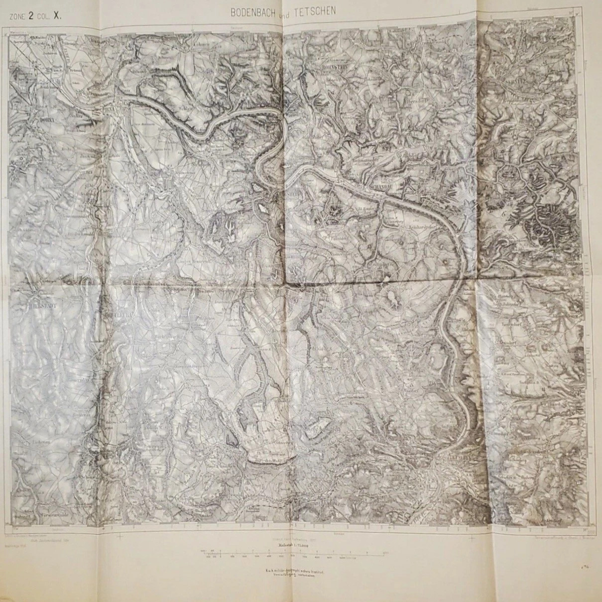
Offered here is an original Austro-Hungarian military topographic map titled:
BODENBACH und TETSCHEN
The sheet was produced by the k.u.k. militär-geographisches Institut and is marked:
The map therefore incorporates the 1896 corrections and is best described as a circa 1896–early 1900s Austro-Hungarian military map, rather than a map printed in 1877.
Regimental provenance
The reverse carries an original military property stamp reading:
K. und k. Infanterieregiment
Freiherr von Mollinary Nr. 38
3. and Royal Infantry Regiment Freiherr von Mollinary No. 38 — 3rd Field Company
The large handwritten notation on the reverse repeated the map’s title so the sheet could be identified while folded.
The regimental stamp is the most important feature of this example. It identifies the map as military property belonging to the 3rd Field Company of Austro-Hungarian Infantry Regiment No. 38, rather than an ordinary civilian or library map.
Geographic coverage
The map depicts the northern Bohemian and Saxon border region around:
Bodenbach — modern Podmokly
Tetschen — modern Děčín
The Elbe River corridor
Aussig — modern Ústí nad Labem
Teplitz-Schönau — modern Teplice
Leitmeritz — modern Litoměřice
Adjacent Saxon territory
Railways, roads, settlements, waterways, forests and elevations
The 1:75,000 scale provided military planners with detailed regional coverage suitable for route planning, troop movement, logistical study and field exercises.
Printed cartographic information
Visible printed details include:
BODENBACH und TETSCHEN
Map title
ZONE 2 COL. X.
Original sheet-grid designation
Maßstab 1:75.000
Scale 1:75,000
Inland nach Aufnahme 1877
Interior territory based on the 1877 survey
Nach Zeichenschlüssel 1894
Prepared according to the 1894 map-symbol key
Nachträge 1896
Corrections or additions made in 1896
K.u.k. militär-geographisches Institut
Imperial and Royal Military Geographical Institute
Vervielfältigung vorbehalten
Reproduction reserved
Historical significance
This is a pre-WWI Austro-Hungarian military-property map associated with a specifically identified regiment and company.
The map may have remained in military inventory into the First World War, but there are no dated wartime operational annotations proving battlefield use. It is most accurately offered as an original pre-WWI KUK regimental military map with possible continued service use.
The combination of:
exact named map sheet;
detailed military topography;
original regimental property stamp;
company designation;
handwritten field cartographic update information;
makes this a stronger militaria collectible than an unmarked copy of the same map.
Condition
Please examine all photographs carefully, as they form an important part of the description.
The map remains substantially complete but shows extensive evidence of age, military handling and prolonged folded storage, including:
Heavy original fold lines throughout
Darkening, grime and wear concentrated along the folds
Small holes and areas of paper loss where folds intersect
Several edge tears, notches and small losses
Noticeable triangular loss or tear along one upper edge
Notched loss along the lower edge
Corner creasing and folded corners
Scattered staining, spotting and foxing
General yellowing and age toning
Surface soiling and handling marks
Small punctures or pinholes
Localized thinning and weakness along fold lines
Waviness and unevenness from storage
Dark staining or transferred dirt across portions of the map image
No cloth backing
No modern tape repairs observed in the photographs
Regimental stamp remains readable
Handwritten Bodenbach/Tetschen identification remains visible
Printed map detail remains extensive and generally legible
The sheet should be handled carefully because the intersecting folds have weakened in several places.
The map has not been cleaned, flattened, repaired or restored.
Exact unfolded dimensions: [insert measurements]
Collector appeal
A desirable original piece for collectors of:
Austro-Hungarian militaria
KUK Army artifacts
Imperial Austrian military maps
World War I-era cartography
Infantry Regiment No. 38
Bohemian and Sudetenland history
Děčín, Bodenbach and Tetschen local history
Antique topographic maps
Military geographical institutes
This historical item is offered solely for collecting, research and educational purposes.
Shipping
FREE SHIPPING TO THE UNITED STATES AND CANADA
The map will be shipped folded along its existing original folds, protected inside archival-safe material and reinforced rigid packaging. Ships with tracking.
Please visit our store for additional original WWI and WWII militaria, military maps, documents, photographs, medals and antique historical collectibles.
Item specifics
Conflict: WW I (1914–18)
Original/Reproduction: Original
Region of Origin: Austria-Hungary
Country of Origin: Austria
Theme: Militaria
Type: Military Topographic Map
Map Title: Bodenbach und Tetschen
Sheet Designation: Zone 2, Colonne X
Scale: 1:75,000
Date: Circa 1896–Early 1900s
Survey Date: 1877
Cartographic Update: 1896
Publisher: k.u.k. Militärgeographisches Institut
Place of Publication: Vienna, Austria-Hungary
Military Unit: k.u.k. Infanterieregiment Freiherr von Mollinary Nr. 38
Company: 3. Feldkompagnie
Subject: Northern Bohemia and Saxony
Locations: Bodenbach, Tetschen, Děčín, Podmokly, Elbe River
Language: German
Material: Paper
Format: Folding Sheet Map
Handwritten: Yes
Stamped: Yes — Regimental Property Stamp
Modified Item: No known modern modifications
Condition: Used — see full description and photographs
Dimensions: [insert unfolded dimensions]