
1966 Map of Mount Desert Island | Frenchman Bay | Schoodic Peninsula | Pictorial For Sale

When you click on links to various merchants on this site and make a purchase, this can result in this site earning a commission. Affiliate programs and affiliations include, but are not limited to, the eBay Partner Network.

1966 Map of Mount Desert Island | Frenchman Bay | Schoodic Peninsula | Pictorial:
$33.99
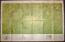
Map size: 18 inches x 2 feet (60.96cm x 45.72cm) | Ready to frame in standard size frame (18x24) | Frame not included | Archival quality reproductionA very attractive 1966 pictorial map of Mount Desert Island, Frenchman bay, and the Schoodic Peninsula. The map was drawn by Augustus D. Phillips, a Northeast Harbor native, in, memory of George B. Dorr, Charles, W. Eliot, and John D. Rockefeller Jr. who together in, 1919, created Acadia National Park. Today Acadia is one of the finest national parks on the eastern seaboard and is enjoyed by thousands of adventurers each year. Augustus D. Phillips was the brother of Luther S. Phillips (1930 -1850) who published a number of pictorial maps under the imprint of his company, Map of Maine. Powered by SixBit\'s eCommerce Solution
|
Other Related Items:
Related Items:
1966 India Agra City Of The Taj Travel Brochure & Map Vintage Printed In India $13.45
6536 i S - US Army - 1966 MAP - Ia Drang Valley - Hwy 19 - Vietnam War - Ia Mur $150.00
Vintage Crewel Embroidered Linen HISTORY OF TRANSPORTATION 1966 & USA MAP 1967 $169.94
|